This weather event on April 22, 2025 includes:
2 states
20 counties,
17 cities,
and 67 zip codes.
There were 5929 total properties that were impacted and have possible damage.
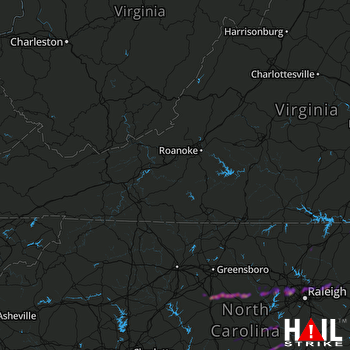 ROANOKE (KFCX) RADAR
States Impacted By Hail On April 22, 2025
North Carolina
·
Virginia
Counties Impacted By Hail On April 22, 2025
Alamance, NC
·
Chatham, NC
·
Durham, NC
·
Franklin, NC
·
Granville, NC
·
Halifax, NC
·
Harnett, NC
·
Hoke, NC
·
Johnston, NC
·
Lee, NC
·
Montgomery, NC
·
Moore, NC
·
Nash, NC
·
Northampton, NC
·
Orange, NC
·
Randolph, NC
·
Richmond, NC
·
Wake, NC
·
Warren, NC
·
Brunswick, VA
Cities Impacted By Hail On April 22, 2025
Asheboro, NC
·
Broadway, NC
·
Carrboro, NC
·
Chapel Hill, NC
·
Fearrington Village, NC
·
Gasburg, VA
·
Liberty, NC
·
Macon, NC
·
Morrisville, NC
·
Norman, NC
·
Oxford, NC
·
Ramseur, NC
·
Randleman, NC
·
Rolesville, NC
·
Sanford, NC
·
Staley, NC
·
Wake Forest, NC
Zip Codes Impacted By Hail On April 22, 2025
23857
·
23887
·
27203
·
27205
·
27229
·
27233
·
27248
·
27253
·
27281
·
27298
·
27312
·
27316
·
27317
·
27330
·
27332
·
27344
·
27349
·
27350
·
27355
·
27370
·
27376
·
27504
·
27505
·
27510
·
27513
·
27514
·
27516
·
27517
·
27519
·
27520
·
27523
·
27524
·
27545
·
27546
·
27551
·
27557
·
27560
·
27565
·
27571
·
27587
·
27591
·
27597
·
27607
·
27609
·
27612
·
27613
·
27614
·
27615
·
27617
·
27703
·
27713
·
27832
·
27842
·
27850
·
27870
·
27882
·
28315
·
28323
·
28326
·
28327
·
28338
·
28367
·
28390
·
28394
·
27526
·
27596
·
27616

