This weather event on April 22, 2025 includes:
3 states
31 counties,
13 cities,
and 69 zip codes.
There were 2078 total properties that were impacted and have possible damage.
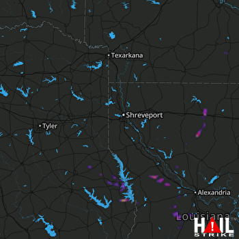 SHREVEPORT (KSHV) RADAR
States Impacted By Hail On April 22, 2025
Arkansas
·
Louisiana
·
Texas
Counties Impacted By Hail On April 22, 2025
Calhoun, AR
·
Dallas, AR
·
Drew, AR
·
Allen, LA
·
Avoyelles, LA
·
Bienville, LA
·
Caldwell, LA
·
Evangeline, LA
·
Franklin, LA
·
Grant, LA
·
Jackson, LA
·
LaSalle, LA
·
Lincoln, LA
·
Madison, LA
·
Natchitoches, LA
·
Ouachita, LA
·
Rapides, LA
·
Red River, LA
·
Richland, LA
·
Sabine, LA
·
Tensas, LA
·
Union, LA
·
Vernon, LA
·
West Carroll, LA
·
Winn, LA
·
Angelina, TX
·
Nacogdoches, TX
·
Newton, TX
·
Sabine, TX
·
San Augustine, TX
·
Shelby, TX
Cities Impacted By Hail On April 22, 2025
Ashland, LA
·
Bunkie, LA
·
Claiborne, LA
·
Dodson, LA
·
Elizabeth, LA
·
Farmerville, LA
·
Glenmora, LA
·
Hemphill, TX
·
Lakeshore, LA
·
McNary, LA
·
Milam, TX
·
Monroe, LA
·
Simpson, LA
Zip Codes Impacted By Hail On April 22, 2025
70586
·
70638
·
70655
·
70656
·
71016
·
71019
·
71070
·
71202
·
71203
·
71225
·
71226
·
71227
·
71232
·
71234
·
71237
·
71238
·
71241
·
71266
·
71269
·
71291
·
71292
·
71295
·
71322
·
71328
·
71357
·
71403
·
71404
·
71409
·
71416
·
71417
·
71418
·
71422
·
71423
·
71429
·
71430
·
71433
·
71435
·
71438
·
71446
·
71447
·
71454
·
71455
·
71457
·
71463
·
71466
·
71468
·
71469
·
71472
·
71473
·
71474
·
71642
·
71655
·
71675
·
71720
·
71744
·
75930
·
75932
·
75935
·
75946
·
75948
·
75959
·
75961
·
75972
·
75973
·
75977
·
75980
·
71427
·
71343
·
71251

