This weather event on April 11, 2025 includes:
1 states
14 counties,
23 cities,
and 56 zip codes.
There were 1153 total properties that were impacted and have possible damage.
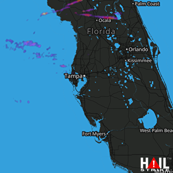 TAMPA (KTBW) RADAR
States Impacted By Hail On April 11, 2025
Florida
Counties Impacted By Hail On April 11, 2025
Alachua, FL
·
Bradford, FL
·
Clay, FL
·
Dixie, FL
·
Flagler, FL
·
Gilchrist, FL
·
Hernando, FL
·
Lake, FL
·
Levy, FL
·
Marion, FL
·
Pasco, FL
·
Pinellas, FL
·
Putnam, FL
·
Volusia, FL
Cities Impacted By Hail On April 11, 2025
Andrews, FL
·
Brooksville, FL
·
Bunnell, FL
·
Chiefland, FL
·
Clearwater, FL
·
Dunedin, FL
·
East Williston, FL
·
Gainesville, FL
·
Greenbriar, FL
·
Holiday, FL
·
Keystone Heights, FL
·
Manatee Road, FL
·
McIntosh, FL
·
Newberry, FL
·
Oldsmar, FL
·
Palm Harbor, FL
·
Safety Harbor, FL
·
Seville, FL
·
South Brooksville, FL
·
Spring Hill, FL
·
Tarpon Springs, FL
·
Williston, FL
·
Williston Highlands, FL
Zip Codes Impacted By Hail On April 11, 2025
32091
·
32102
·
32110
·
32112
·
32113
·
32134
·
32139
·
32180
·
32190
·
32605
·
32606
·
32609
·
32615
·
32617
·
32618
·
32621
·
32626
·
32631
·
32640
·
32648
·
32653
·
32656
·
32664
·
32666
·
32667
·
32668
·
32669
·
32680
·
32681
·
32686
·
32693
·
32694
·
32696
·
33523
·
33525
·
33759
·
33761
·
33763
·
34475
·
34479
·
34482
·
34488
·
34601
·
34602
·
34604
·
34609
·
34614
·
34652
·
34668
·
34677
·
34683
·
34684
·
34689
·
34691
·
34695
·
34698

