This weather event on April 10, 2025 includes:
4 states
29 counties,
24 cities,
and 70 zip codes.
There were 9425 total properties that were impacted and have possible damage.
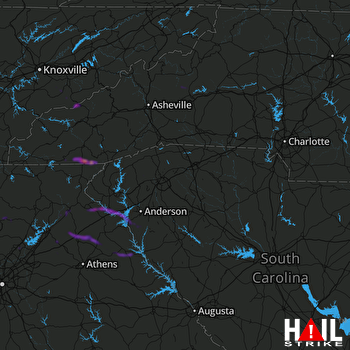 GREER (KGSP) RADAR
States Impacted By Hail On April 10, 2025
Georgia
·
North Carolina
·
South Carolina
·
Tennessee
Counties Impacted By Hail On April 10, 2025
Banks, GA
·
Cherokee, GA
·
Dawson, GA
·
Elbert, GA
·
Forsyth, GA
·
Franklin, GA
·
Gwinnett, GA
·
Habersham, GA
·
Hall, GA
·
Hart, GA
·
Jackson, GA
·
Madison, GA
·
Pickens, GA
·
Rabun, GA
·
Stephens, GA
·
Union, GA
·
White, GA
·
Clay, NC
·
Macon, NC
·
Madison, NC
·
McDowell, NC
·
Swain, NC
·
Yancey, NC
·
Abbeville, SC
·
Anderson, SC
·
Oconee, SC
·
Pickens, SC
·
Blount, TN
·
Sevier, TN
Cities Impacted By Hail On April 10, 2025
Antreville, SC
·
Arcade, GA
·
Baldwin, GA
·
Braselton, GA
·
Commerce, GA
·
Cornelia, GA
·
Demorest, GA
·
Elberton, GA
·
Fair Play, SC
·
Gainesville, GA
·
Gatlinburg, TN
·
Gumlog, GA
·
Highlands, NC
·
Holly Springs, GA
·
Hoschton, GA
·
Jasper, GA
·
Maysville, GA
·
Pickens, SC
·
Raoul, GA
·
Reed Creek, GA
·
Starr, SC
·
Talmo, GA
·
Toccoa, GA
·
Woodstock, GA
Zip Codes Impacted By Hail On April 10, 2025
28714
·
28719
·
28734
·
28741
·
28752
·
28753
·
28763
·
28775
·
28904
·
29620
·
29626
·
29640
·
29643
·
29655
·
29671
·
29678
·
29684
·
29689
·
29693
·
30004
·
30019
·
30040
·
30041
·
30107
·
30143
·
30148
·
30175
·
30177
·
30188
·
30504
·
30506
·
30507
·
30510
·
30512
·
30517
·
30519
·
30521
·
30525
·
30527
·
30528
·
30529
·
30530
·
30531
·
30534
·
30535
·
30537
·
30538
·
30543
·
30547
·
30548
·
30549
·
30553
·
30554
·
30557
·
30558
·
30563
·
30567
·
30575
·
30577
·
30624
·
30627
·
30629
·
30633
·
30634
·
30635
·
30643
·
30662
·
37738
·
37862
·
37865

