This weather event on April 2, 2025 includes:
3 states
22 counties,
23 cities,
and 87 zip codes.
There were 14770 total properties that were impacted and have possible damage.
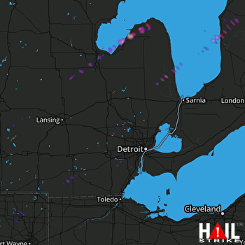 DETROIT (KDTX) RADAR
States Impacted By Hail On April 2, 2025
Indiana
·
Michigan
·
Ohio
Counties Impacted By Hail On April 2, 2025
LaGrange, IN
·
Noble, IN
·
Steuben, IN
·
Allegan, MI
·
Barry, MI
·
Bay, MI
·
Branch, MI
·
Clinton, MI
·
Gratiot, MI
·
Hillsdale, MI
·
Huron, MI
·
Ionia, MI
·
Jackson, MI
·
Lenawee, MI
·
Saginaw, MI
·
Sanilac, MI
·
Shiawassee, MI
·
St. Joseph, MI
·
Tuscola, MI
·
Washtenaw, MI
·
Wayne, MI
·
Defiance, OH
Cities Impacted By Hail On April 2, 2025
Addison, MI
·
Albion, IN
·
Bay City, MI
·
Bay Port, MI
·
Belleville, MI
·
Essexville, MI
·
Freeland, MI
·
Hemlock, MI
·
Hillsdale, MI
·
Kendallville, IN
·
Kinde, MI
·
Manitou Beach-Devils Lake, MI
·
Middleville, MI
·
Montgomery, MI
·
North Adams, MI
·
Pigeon, MI
·
Port Sanilac, MI
·
Reading, MI
·
Romulus, MI
·
Sebewaing, MI
·
Sturgis, MI
·
Wayne, MI
·
Wolcottville, IN
Zip Codes Impacted By Hail On April 2, 2025
43506
·
43526
·
43536
·
43556
·
46565
·
46701
·
46737
·
46746
·
46755
·
46784
·
46794
·
46795
·
48111
·
48160
·
48174
·
48184
·
48190
·
48191
·
48401
·
48416
·
48417
·
48419
·
48422
·
48432
·
48445
·
48454
·
48466
·
48467
·
48469
·
48601
·
48603
·
48604
·
48609
·
48615
·
48616
·
48623
·
48626
·
48637
·
48649
·
48655
·
48662
·
48706
·
48708
·
48720
·
48725
·
48731
·
48732
·
48747
·
48755
·
48757
·
48759
·
48767
·
48815
·
48831
·
48849
·
48866
·
48867
·
48881
·
49030
·
49040
·
49058
·
49091
·
49220
·
49221
·
49229
·
49230
·
49233
·
49242
·
49247
·
49249
·
49253
·
49255
·
49256
·
49262
·
49268
·
49271
·
49274
·
49279
·
49325
·
49333
·
49344
·
49348
·
49266
·
49080
·
48847
·
48197
·
46761

