This weather event on March 29, 2025 includes:
5 states
45 counties,
54 cities,
and 161 zip codes.
There were 12602 total properties that were impacted and have possible damage.
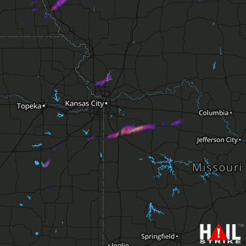 KANSAS CITY (KEAX) RADAR
States Impacted By Hail On March 29, 2025
Iowa
·
Kansas
·
Missouri
·
Nebraska
·
Oklahoma
Counties Impacted By Hail On March 29, 2025
Page, IA
·
Ringgold, IA
·
Taylor, IA
·
Allen, KS
·
Anderson, KS
·
Cherokee, KS
·
Coffey, KS
·
Franklin, KS
·
Greenwood, KS
·
Johnson, KS
·
Leavenworth, KS
·
Linn, KS
·
Miami, KS
·
Osage, KS
·
Wilson, KS
·
Woodson, KS
·
Atchison, MO
·
Barton, MO
·
Bates, MO
·
Benton, MO
·
Caldwell, MO
·
Carroll, MO
·
Cass, MO
·
Cedar, MO
·
Clay, MO
·
Clinton, MO
·
Dade, MO
·
Gentry, MO
·
Harrison, MO
·
Jackson, MO
·
Jasper, MO
·
Johnson, MO
·
Nodaway, MO
·
Pettis, MO
·
Platte, MO
·
Putnam, MO
·
Ray, MO
·
Sullivan, MO
·
Worth, MO
·
Johnson, NE
·
Nemaha, NE
·
Otoe, NE
·
Richardson, NE
·
Craig, OK
·
Ottawa, OK
Cities Impacted By Hail On March 29, 2025
Allendale, MO
·
Auburn, NE
·
Baxter Springs, KS
·
Blanchard, IA
·
Blanchard, MO
·
Blue Springs, MO
·
Butler, MO
·
Centerview, MO
·
College Springs, IA
·
De Soto, KS
·
Drexel, MO
·
East Lynne, MO
·
Freeman, MO
·
Galena, KS
·
Greenwood, MO
·
Gunn City, MO
·
Harrisonville, MO
·
Holden, MO
·
Hughesville, MO
·
Kansas City, MO
·
Kingsville, MO
·
Knob Noster, MO
·
Lake Annette, MO
·
Lake Lotawana, MO
·
La Monte, MO
·
Lansing, KS
·
Leavenworth, KS
·
Lee's Summit, MO
·
Lenexa, KS
·
Louisburg, KS
·
Lowell, KS
·
Olathe, KS
·
Ottawa, KS
·
Paola, KS
·
Peculiar, MO
·
Piqua, KS
·
Platte City, MO
·
Pleasant Hill, MO
·
Riverton, KS
·
Rock Port, MO
·
Shambaugh, IA
·
Shawnee, KS
·
Smithville, MO
·
Spring Hill, KS
·
Strasburg, MO
·
Tarkio, MO
·
Tracy, MO
·
Trimble, MO
·
Warrensburg, MO
·
Waverly, KS
·
Welch, OK
·
Westboro, MO
·
West Line, MO
·
Williamsburg, KS
Zip Codes Impacted By Hail On March 29, 2025
64018
·
64019
·
64029
·
64034
·
64035
·
64040
·
64061
·
64064
·
64075
·
64078
·
64079
·
64080
·
64084
·
64085
·
64086
·
64089
·
64090
·
64092
·
64093
·
64098
·
64152
·
64153
·
64155
·
64163
·
64164
·
64165
·
64402
·
64420
·
64428
·
64431
·
64444
·
64445
·
64446
·
64453
·
64456
·
64458
·
64465
·
64475
·
64476
·
64477
·
64482
·
64491
·
64492
·
64496
·
65326
·
65333
·
65334
·
65336
·
65337
·
65347
·
65603
·
65634
·
65635
·
65785
·
66013
·
66014
·
66015
·
66018
·
66095
·
66226
·
66227
·
66510
·
74354
·
74363
·
74369
·
50833
·
50835
·
50845
·
50848
·
50851
·
50854
·
50862
·
50863
·
51630
·
51631
·
51632
·
51636
·
51637
·
51640
·
51646
·
51647
·
63545
·
63560
·
63565
·
64461
·
64498
·
64499
·
64622
·
64624
·
64633
·
64637
·
64643
·
64668
·
64671
·
64682
·
64701
·
64722
·
64725
·
64730
·
64734
·
64739
·
64742
·
64743
·
64746
·
64747
·
64769
·
64779
·
64832
·
64855
·
65301
·
66020
·
66025
·
66030
·
66039
·
66048
·
66052
·
66053
·
66061
·
66062
·
66064
·
66067
·
66071
·
66072
·
66076
·
66078
·
66079
·
66083
·
66092
·
66093
·
66218
·
66220
·
66528
·
66713
·
66714
·
66725
·
66736
·
66739
·
66749
·
66757
·
66758
·
66761
·
66770
·
66777
·
66783
·
66839
·
66852
·
66871
·
67047
·
67336
·
68305
·
68320
·
68321
·
68376
·
68378
·
68410
·
68414
·
68421
·
68437
·
68447
·
68457
·
74333

