This weather event on March 29, 2025 includes:
3 states
23 counties,
26 cities,
and 65 zip codes.
There were 4197 total properties that were impacted and have possible damage.
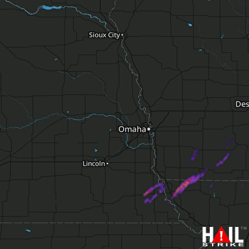 OMAHA (KOAX) RADAR
States Impacted By Hail On March 29, 2025
Iowa
·
Missouri
·
Nebraska
Counties Impacted By Hail On March 29, 2025
Adair, IA
·
Adams, IA
·
Audubon, IA
·
Calhoun, IA
·
Cass, IA
·
Fremont, IA
·
Greene, IA
·
Madison, IA
·
Montgomery, IA
·
Page, IA
·
Polk, IA
·
Ringgold, IA
·
Taylor, IA
·
Union, IA
·
Warren, IA
·
Atchison, MO
·
Nodaway, MO
·
Worth, MO
·
Johnson, NE
·
Nemaha, NE
·
Otoe, NE
·
Pawnee, NE
·
Richardson, NE
Cities Impacted By Hail On March 29, 2025
Afton, IA
·
Allendale, MO
·
Auburn, NE
·
Blanchard, IA
·
Blanchard, MO
·
Brock, NE
·
Clarinda, IA
·
College Springs, IA
·
Des Moines, IA
·
Grant City, MO
·
Gravity, IA
·
Hopkins, MO
·
Indianola, IA
·
Johnson, NE
·
Lenox, IA
·
Lorimor, IA
·
New Market, IA
·
Norwalk, IA
·
Peru, NE
·
Prescott, IA
·
Rock Port, MO
·
Shambaugh, IA
·
Sharpsburg, IA
·
Stanton, IA
·
Tarkio, MO
·
Westboro, MO
Zip Codes Impacted By Hail On March 29, 2025
50020
·
50022
·
50050
·
50076
·
50125
·
50149
·
50155
·
50211
·
50222
·
50254
·
50273
·
50274
·
50312
·
50321
·
50801
·
50830
·
50833
·
50841
·
50845
·
50846
·
50848
·
50849
·
50851
·
50854
·
50858
·
50859
·
50860
·
50861
·
50862
·
50864
·
51453
·
51566
·
51573
·
51601
·
51630
·
51631
·
51632
·
51636
·
51637
·
51638
·
51639
·
51640
·
51646
·
51647
·
64420
·
64445
·
64446
·
64456
·
64476
·
64482
·
64491
·
64496
·
64498
·
68305
·
68320
·
68378
·
68410
·
68414
·
68421
·
68437
·
68447
·
68450
·
68376
·
68321
·
64461

