This weather event on March 25, 2025 includes:
2 states
16 counties,
39 cities,
and 59 zip codes.
There were 5191 total properties that were impacted and have possible damage.
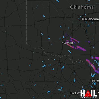 ALTUS AFB (KFDR) RADAR
States Impacted By Hail On March 25, 2025
Oklahoma
·
Texas
Counties Impacted By Hail On March 25, 2025
Bryan, OK
·
Caddo, OK
·
Carter, OK
·
Comanche, OK
·
Cotton, OK
·
Garvin, OK
·
Grady, OK
·
Johnston, OK
·
Kiowa, OK
·
Love, OK
·
Marshall, OK
·
Murray, OK
·
Stephens, OK
·
Washita, OK
·
Cooke, TX
·
Grayson, TX
Cities Impacted By Hail On March 25, 2025
Apache, OK
·
Ardmore, OK
·
Bee, OK
·
Bray, OK
·
Burneyville, OK
·
Callisburg, TX
·
Central High, OK
·
Collinsville, TX
·
Comanche, OK
·
Cyril, OK
·
Davis, OK
·
Denison, TX
·
Dickson, OK
·
Duncan, OK
·
Elgin, OK
·
Empire City, OK
·
Fletcher, OK
·
Gunter, TX
·
Kingston, OK
·
Knollwood, TX
·
Lake Kiowa, TX
·
Lebanon, OK
·
Madill, OK
·
Marlow, OK
·
Meridian, OK
·
Oakland, OK
·
Oak Ridge, TX
·
Pauls Valley, OK
·
Ravia, OK
·
Rush Springs, OK
·
Sadler, TX
·
Sherman, TX
·
Silo, OK
·
Southmayd, TX
·
Sulphur, OK
·
Thackerville, OK
·
Velma, OK
·
Whitesboro, TX
·
Wynnewood, OK
Zip Codes Impacted By Hail On March 25, 2025
73002
·
73005
·
73006
·
73015
·
73017
·
73029
·
73075
·
73098
·
73401
·
73425
·
73430
·
73433
·
73437
·
73438
·
73439
·
73440
·
73442
·
73450
·
73453
·
73455
·
73458
·
73459
·
73460
·
73463
·
73481
·
73501
·
73507
·
73529
·
73533
·
73538
·
73541
·
73572
·
75090
·
76233
·
76273
·
76271
·
76268
·
76264
·
76240
·
75459
·
75092
·
75058
·
75020
·
74856
·
74748
·
74701
·
73632
·
73491
·
73449
·
73448
·
73446
·
73434
·
73086
·
73082
·
73067
·
73055
·
73048
·
73038
·
73030

