This weather event on March 12, 2025 includes:
1 states
20 counties,
24 cities,
and 75 zip codes.
There were 4868 total properties that were impacted and have possible damage.
States Impacted By Hail On March 12, 2025
Texas
Counties Impacted By Hail On March 12, 2025
Anderson, TX
·
Bell, TX
·
Brazos, TX
·
Cherokee, TX
·
Ellis, TX
·
Falls, TX
·
Freestone, TX
·
Grimes, TX
·
Henderson, TX
·
Hill, TX
·
Houston, TX
·
Leon, TX
·
Limestone, TX
·
Madison, TX
·
McLennan, TX
·
Milam, TX
·
Navarro, TX
·
Robertson, TX
·
Rusk, TX
·
Williamson, TX
Cities Impacted By Hail On March 12, 2025
Blooming Grove, TX
·
Bryan, TX
·
Caney City, TX
·
College Station, TX
·
Corsicana, TX
·
Elkhart, TX
·
Frankston, TX
·
Hallsburg, TX
·
Hilltop Lakes, TX
·
Kerens, TX
·
Madisonville, TX
·
Malakoff, TX
·
Mexia, TX
·
Midway, TX
·
Milford, TX
·
New Summerfield, TX
·
Normangee, TX
·
Palestine, TX
·
Powell, TX
·
Reklaw, TX
·
Richland, TX
·
Star Harbor, TX
·
Teague, TX
·
Trinidad, TX
Zip Codes Impacted By Hail On March 12, 2025
75102
·
75109
·
75110
·
75124
·
75143
·
75144
·
75148
·
75153
·
75156
·
75163
·
75654
·
75667
·
75751
·
75752
·
75763
·
75766
·
75770
·
75784
·
75785
·
75789
·
75801
·
75803
·
75831
·
75833
·
75839
·
75840
·
75844
·
75846
·
75852
·
75855
·
75860
·
75925
·
76501
·
76511
·
76519
·
76520
·
76534
·
76570
·
76574
·
76624
·
76626
·
76629
·
76635
·
76641
·
76642
·
76648
·
76651
·
76653
·
76656
·
76661
·
76664
·
76667
·
76670
·
76673
·
76678
·
76680
·
76681
·
76687
·
77801
·
77802
·
77807
·
77808
·
77837
·
77840
·
77845
·
77855
·
77856
·
77859
·
77861
·
77864
·
77865
·
77871
·
77872
·
78615
·
78621
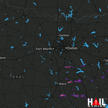 DALLAS/FTW (KFWS) RADAR

