This weather event on December 31, 2024 includes:
1 states
17 counties,
14 cities,
and 53 zip codes.
There were 8657 total properties that were impacted and have possible damage.
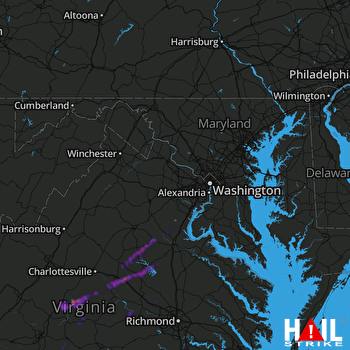 STERLING (KLWX) RADAR
States Impacted By Hail On December 31, 2024
Virginia
Counties Impacted By Hail On December 31, 2024
Albemarle, VA
·
Appomattox, VA
·
Buckingham, VA
·
Campbell, VA
·
Culpeper, VA
·
Cumberland, VA
·
Fauquier, VA
·
Fluvanna, VA
·
Frederick, VA
·
Goochland, VA
·
Hanover, VA
·
Louisa, VA
·
Nelson, VA
·
Orange, VA
·
Powhatan, VA
·
Spotsylvania, VA
·
Stafford, VA
Cities Impacted By Hail On December 31, 2024
Arrington, VA
·
Blue Ridge Shores, VA
·
Esmont, VA
·
Goochland, VA
·
Gordonsville, VA
·
Lake Holiday, VA
·
Lake Monticello, VA
·
Lake of the Woods, VA
·
Louisa, VA
·
Lovingston, VA
·
Mineral, VA
·
Schuyler, VA
·
Scottsville, VA
·
Shipman, VA
Zip Codes Impacted By Hail On December 31, 2024
22134
·
22406
·
22407
·
22508
·
22534
·
22542
·
22551
·
22553
·
22554
·
22556
·
22567
·
22603
·
22637
·
22701
·
22720
·
22726
·
22733
·
22736
·
22902
·
22922
·
22937
·
22942
·
22946
·
22949
·
22960
·
22963
·
22964
·
22967
·
22971
·
22974
·
23024
·
23027
·
23040
·
23063
·
23084
·
23093
·
23102
·
23117
·
23139
·
23146
·
23153
·
23192
·
23921
·
23936
·
24521
·
24522
·
24538
·
24553
·
24562
·
24590
·
24593
·
24599
·
22969

