This weather event on December 18, 2024 includes:
3 states
31 counties,
15 cities,
and 73 zip codes.
There were 656 total properties that were impacted and have possible damage.
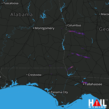 FORT RUCKER (KEOX) RADAR
States Impacted By Hail On December 18, 2024
Alabama
·
Florida
·
Georgia
Counties Impacted By Hail On December 18, 2024
Coffee, AL
·
Dale, AL
·
Geneva, AL
·
Houston, AL
·
Macon, AL
·
Russell, AL
·
Gadsden, FL
·
Holmes, FL
·
Jackson, FL
·
Leon, FL
·
Walton, FL
·
Washington, FL
·
Baker, GA
·
Calhoun, GA
·
Chattahoochee, GA
·
Decatur, GA
·
Dooly, GA
·
Dougherty, GA
·
Early, GA
·
Lee, GA
·
Marion, GA
·
Miller, GA
·
Mitchell, GA
·
Quitman, GA
·
Randolph, GA
·
Schley, GA
·
Seminole, GA
·
Stewart, GA
·
Sumter, GA
·
Terrell, GA
·
Webster, GA
Cities Impacted By Hail On December 18, 2024
Americus, GA
·
Baconton, GA
·
Bainbridge, GA
·
Bonifay, FL
·
Chipley, FL
·
Cusseta-Chattahoochee County, GA
·
Georgetown-Quitman County, GA
·
Hartford, AL
·
Iron City, GA
·
Leary, GA
·
Leesburg, GA
·
Midway, FL
·
Slocomb, AL
·
Tallahassee, FL
·
Webster County, GA
Zip Codes Impacted By Hail On December 18, 2024
31070
·
31092
·
31716
·
31719
·
31721
·
31730
·
31744
·
31763
·
31780
·
31784
·
31803
·
31805
·
31806
·
31814
·
31815
·
31821
·
31824
·
31905
·
32301
·
32303
·
32304
·
32308
·
32309
·
32311
·
32312
·
32317
·
32333
·
32343
·
32351
·
32423
·
32425
·
32426
·
32427
·
32428
·
32431
·
32433
·
32443
·
32445
·
32446
·
32448
·
32455
·
32460
·
32464
·
36320
·
36330
·
36343
·
36344
·
36352
·
36375
·
36856
·
36860
·
36869
·
36871
·
39813
·
39817
·
39819
·
39823
·
39824
·
39825
·
39837
·
39842
·
39845
·
39846
·
39854
·
39859
·
39862
·
39866
·
39867
·
39870
·
39886
·
39840
·
36875
·
31825

