This weather event on October 24, 2024 includes:
2 states
23 counties,
14 cities,
and 79 zip codes.
There were 1641 total properties that were impacted and have possible damage.
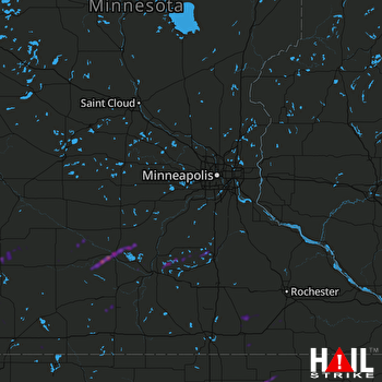 MINNEAPOLIS (KMPX) RADAR
States Impacted By Hail On October 24, 2024
Iowa
·
Minnesota
Counties Impacted By Hail On October 24, 2024
Cerro Gordo, IA
·
Floyd, IA
·
Hancock, IA
·
Kossuth, IA
·
Mitchell, IA
·
Blue Earth, MN
·
Brown, MN
·
Dodge, MN
·
Freeborn, MN
·
Jackson, MN
·
Le Sueur, MN
·
Lyon, MN
·
Mower, MN
·
Murray, MN
·
Nicollet, MN
·
Nobles, MN
·
Redwood, MN
·
Renville, MN
·
Rice, MN
·
Sibley, MN
·
Steele, MN
·
Waseca, MN
·
Watonwan, MN
Cities Impacted By Hail On October 24, 2024
Dundas, MN
·
Lismore, MN
·
Mankato, MN
·
Mason City, IA
·
Milroy, MN
·
New Haven, IA
·
New Ulm, MN
·
Nora Springs, IA
·
Northfield, MN
·
Orchard, IA
·
Osage, IA
·
Portland, IA
·
Waltham, MN
·
Wilmont, MN
Zip Codes Impacted By Hail On October 24, 2024
50401
·
50428
·
50438
·
50458
·
50460
·
50461
·
50466
·
50471
·
50477
·
50479
·
50482
·
50560
·
55019
·
55021
·
55052
·
55057
·
55060
·
55332
·
55333
·
55334
·
55912
·
55917
·
55926
·
55936
·
55940
·
55967
·
55970
·
55973
·
55982
·
56001
·
56003
·
56009
·
56010
·
56017
·
56019
·
56026
·
56036
·
56050
·
56052
·
56054
·
56055
·
56057
·
56058
·
56060
·
56063
·
56069
·
56072
·
56073
·
56074
·
56081
·
56083
·
56085
·
56087
·
56088
·
56093
·
56096
·
56110
·
56115
·
56122
·
56131
·
56132
·
56141
·
56150
·
56155
·
56165
·
56167
·
56168
·
56172
·
56175
·
56185
·
56224
·
56255
·
56258
·
56263
·
56266
·
50449
·
50469
·
55046
·
56082

