This weather event on October 22, 2024 includes:
3 states
16 counties,
18 cities,
and 57 zip codes.
There were 1517 total properties that were impacted and have possible damage.
States Impacted By Hail On October 22, 2024
Iowa
·
Illinois
·
Missouri
Counties Impacted By Hail On October 22, 2024
Davis, IA
·
Des Moines, IA
·
Henry, IA
·
Jefferson, IA
·
Keokuk, IA
·
Lee, IA
·
Louisa, IA
·
Mahaska, IA
·
Van Buren, IA
·
Wapello, IA
·
Washington, IA
·
Adams, IL
·
Pike, IL
·
Lewis, MO
·
Marion, MO
·
Ralls, MO
Cities Impacted By Hail On October 22, 2024
Batavia, IA
·
Baylis, IL
·
Brighton, IA
·
Eddyville, IA
·
Fairfield, IA
·
Floris, IA
·
Hannibal, MO
·
Libertyville, IA
·
Lockridge, IA
·
Maharishi Vedic City, IA
·
Martinsburg, IA
·
Olds, IA
·
Ottumwa, IA
·
Packwood, IA
·
Richland, IA
·
Salem, IA
·
Wayland, IA
·
Winfield, IA
Zip Codes Impacted By Hail On October 22, 2024
52231
·
52248
·
52353
·
52501
·
52530
·
52533
·
52535
·
52537
·
52540
·
52543
·
52550
·
52551
·
52552
·
52553
·
52554
·
52556
·
52557
·
52560
·
52563
·
52567
·
52570
·
52576
·
52577
·
52585
·
52588
·
52591
·
52621
·
52630
·
52635
·
52640
·
52641
·
52644
·
52645
·
52647
·
52649
·
52654
·
52659
·
52738
·
62305
·
62312
·
62314
·
62343
·
62345
·
62347
·
62357
·
62360
·
62361
·
62363
·
62365
·
62366
·
62370
·
63401
·
63435
·
63448
·
63452
·
63461
·
52580
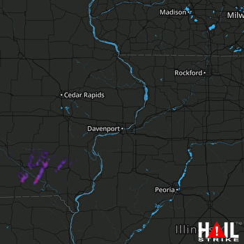 DAVENPORT (KDVN) RADAR

