This weather event on September 24, 2024 includes:
4 states
23 counties,
21 cities,
and 81 zip codes.
There were 7312 total properties that were impacted and have possible damage.
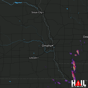 OMAHA (KOAX) RADAR
States Impacted By Hail On September 24, 2024
Iowa
·
Kansas
·
Missouri
·
Nebraska
Counties Impacted By Hail On September 24, 2024
Adair, IA
·
Adams, IA
·
Cass, IA
·
Clarke, IA
·
Guthrie, IA
·
Madison, IA
·
Montgomery, IA
·
Page, IA
·
Taylor, IA
·
Union, IA
·
Brown, KS
·
Doniphan, KS
·
Jackson, KS
·
Marshall, KS
·
Nemaha, KS
·
Pottawatomie, KS
·
Andrew, MO
·
Buchanan, MO
·
Holt, MO
·
Nodaway, MO
·
Johnson, NE
·
Pawnee, NE
·
Richardson, NE
Cities Impacted By Hail On September 24, 2024
Arkoe, MO
·
Braddyville, IA
·
Burlington Junction, MO
·
Corning, IA
·
East Peru, IA
·
Hiawatha, KS
·
Hopkins, MO
·
Maryville, MO
·
Menlo, IA
·
Pickering, MO
·
Prescott, IA
·
Reserve, KS
·
Rosendale, MO
·
Sabetha, KS
·
Savannah, MO
·
Sharpsburg, IA
·
Stanton, IA
·
Vermillion, KS
·
Villisca, IA
·
Wathena, KS
·
White Cloud, KS
Zip Codes Impacted By Hail On September 24, 2024
50002
·
50022
·
50048
·
50115
·
50164
·
50213
·
50222
·
50250
·
50257
·
50274
·
50801
·
50830
·
50833
·
50837
·
50841
·
50846
·
50849
·
50851
·
50857
·
50858
·
50859
·
50862
·
50864
·
51532
·
51535
·
51544
·
51573
·
51631
·
51632
·
51636
·
51646
·
64421
·
64423
·
64427
·
64428
·
64431
·
64434
·
64437
·
64443
·
64445
·
64449
·
64451
·
64454
·
64455
·
64461
·
64468
·
64473
·
64476
·
64483
·
64485
·
64487
·
64503
·
64504
·
64505
·
66035
·
66087
·
66090
·
66094
·
66408
·
66415
·
66418
·
66422
·
66425
·
66432
·
66434
·
66509
·
66515
·
66527
·
66532
·
66534
·
66540
·
66544
·
68323
·
68329
·
68345
·
68381
·
68443
·
68450
·
68337
·
66521
·
64401

