This weather event on September 20, 2024 includes:
2 states
21 counties,
19 cities,
and 68 zip codes.
There were 20 total properties that were impacted and have possible damage.
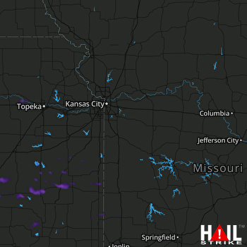 KANSAS CITY (KEAX) RADAR
States Impacted By Hail On September 20, 2024
Kansas
·
Missouri
Counties Impacted By Hail On September 20, 2024
Allen, KS
·
Anderson, KS
·
Bourbon, KS
·
Butler, KS
·
Chase, KS
·
Coffey, KS
·
Crawford, KS
·
Elk, KS
·
Franklin, KS
·
Greenwood, KS
·
Linn, KS
·
Montgomery, KS
·
Neosho, KS
·
Pottawatomie, KS
·
Shawnee, KS
·
Wabaunsee, KS
·
Wilson, KS
·
Woodson, KS
·
Barton, MO
·
Bates, MO
·
Vernon, MO
Cities Impacted By Hail On September 20, 2024
Arma, KS
·
Burgess, MO
·
Cassoday, KS
·
Elk City, KS
·
Eureka, KS
·
Franklin, KS
·
Gas, KS
·
Girard, KS
·
Iola, KS
·
La Harpe, KS
·
Liberal, MO
·
Mulberry, KS
·
Neosho Falls, KS
·
Parker, KS
·
Piqua, KS
·
Rosalia, KS
·
St. Paul, KS
·
Welda, KS
·
Yates Center, KS
Zip Codes Impacted By Hail On September 20, 2024
64752
·
64759
·
64762
·
64769
·
64779
·
66014
·
66015
·
66032
·
66033
·
66039
·
66056
·
66078
·
66080
·
66091
·
66093
·
66095
·
66507
·
66526
·
66533
·
66536
·
66701
·
66712
·
66716
·
66733
·
66735
·
66736
·
66738
·
66743
·
66749
·
66751
·
66754
·
66755
·
66756
·
66757
·
66758
·
66761
·
66767
·
66771
·
66777
·
66783
·
66839
·
66840
·
66842
·
66843
·
66852
·
66853
·
66854
·
66857
·
66860
·
66862
·
66863
·
66865
·
66869
·
66870
·
66871
·
66856
·
66072
·
67042
·
67045
·
67047
·
67074
·
67122
·
67132
·
67137
·
67301
·
67344
·
67349
·
67352

