This weather event on September 19, 2024 includes:
2 states
22 counties,
28 cities,
and 83 zip codes.
There were 5807 total properties that were impacted and have possible damage.
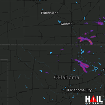 VANCE AFB (KVNX) RADAR
States Impacted By Hail On September 19, 2024
Kansas
·
Oklahoma
Counties Impacted By Hail On September 19, 2024
Butler, KS
·
Chautauqua, KS
·
Cowley, KS
·
Elk, KS
·
Greenwood, KS
·
Montgomery, KS
·
Sumner, KS
·
Wilson, KS
·
Woodson, KS
·
Blaine, OK
·
Creek, OK
·
Dewey, OK
·
Garfield, OK
·
Grant, OK
·
Kay, OK
·
Kingfisher, OK
·
Noble, OK
·
Nowata, OK
·
Osage, OK
·
Pawnee, OK
·
Payne, OK
·
Washington, OK
Cities Impacted By Hail On September 19, 2024
Arkansas City, KS
·
Billings, OK
·
Breckenridge, OK
·
Burden, KS
·
Cedar Vale, KS
·
Climax, KS
·
Coyville, KS
·
Dexter, KS
·
Elk City, KS
·
Enid, OK
·
Geuda Springs, KS
·
Glencoe, OK
·
Hominy, OK
·
Hunter, OK
·
Independence, KS
·
Kellyville, OK
·
Leon, KS
·
Maramec, OK
·
Morrison, OK
·
Neodesha, KS
·
Parkerfield, KS
·
Pawnee, OK
·
Red Rock, OK
·
Sapulpa, OK
·
Shidler, OK
·
Tonkawa, OK
·
Winfield, KS
·
Yale, OK
Zip Codes Impacted By Hail On September 19, 2024
66710
·
66717
·
66736
·
66757
·
66777
·
66783
·
66852
·
66853
·
66863
·
66870
·
67005
·
67008
·
67019
·
67024
·
67038
·
67039
·
67042
·
67045
·
67047
·
67051
·
67072
·
67074
·
67122
·
67131
·
67132
·
67137
·
67140
·
67156
·
67301
·
67346
·
67349
·
67352
·
67353
·
67361
·
73061
·
73077
·
73658
·
73667
·
73701
·
73703
·
73724
·
73738
·
73750
·
73753
·
73755
·
73759
·
73761
·
73763
·
73766
·
73772
·
74020
·
74022
·
74023
·
74029
·
74032
·
74034
·
74035
·
74038
·
74039
·
74045
·
74056
·
74058
·
74066
·
74083
·
74084
·
74601
·
74630
·
74632
·
74633
·
74636
·
74640
·
74643
·
74644
·
74646
·
74647
·
74650
·
74651
·
74652
·
74653
·
67023
·
67119
·
67344
·
74085

