This weather event on August 29, 2024 includes:
2 states
20 counties,
20 cities,
and 49 zip codes.
There were total properties that were impacted and have possible damage.
States Impacted By Hail On August 29, 2024
Arkansas
·
Oklahoma
Counties Impacted By Hail On August 29, 2024
Clark, AR
·
Cleburne, AR
·
Columbia, AR
·
Dallas, AR
·
Faulkner, AR
·
Grant, AR
·
Hempstead, AR
·
Hot Spring, AR
·
Lafayette, AR
·
Nevada, AR
·
Ouachita, AR
·
Pulaski, AR
·
Saline, AR
·
Atoka, OK
·
Coal, OK
·
Hughes, OK
·
McCurtain, OK
·
Pittsburg, OK
·
Pontotoc, OK
·
Pushmataha, OK
Cities Impacted By Hail On August 29, 2024
Ada, OK
·
Arkadelphia, AR
·
Ashland, OK
·
Benton, AR
·
Bodcaw, AR
·
Carthage, AR
·
Centrahoma, OK
·
Haskell, AR
·
Hope, AR
·
Idabel, OK
·
Kiowa, OK
·
Leola, AR
·
Mayflower, AR
·
Patmos, AR
·
Perrytown, AR
·
Quitman, AR
·
Salem, AR
·
Sparkman, AR
·
Traskwood, AR
·
Wardville, OK
Zip Codes Impacted By Hail On August 29, 2024
71701
·
71725
·
71726
·
71743
·
71752
·
71763
·
71764
·
71770
·
71801
·
71827
·
71835
·
71845
·
71858
·
71923
·
71941
·
71962
·
71998
·
71999
·
72015
·
72019
·
72032
·
72034
·
72084
·
72106
·
72122
·
72128
·
72129
·
72131
·
72167
·
74534
·
74538
·
74553
·
74557
·
74558
·
74560
·
74561
·
74569
·
74570
·
74572
·
74574
·
74728
·
74740
·
74745
·
74820
·
74842
·
74871
·
74576
·
74540
·
72118
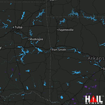 FORT SMITH (KSRX) RADAR

