This weather event on August 29, 2024 includes:
3 states
27 counties,
10 cities,
and 56 zip codes.
There were 461 total properties that were impacted and have possible damage.
States Impacted By Hail On August 29, 2024
Arkansas
·
Louisiana
·
Texas
Counties Impacted By Hail On August 29, 2024
Calhoun, AR
·
Clark, AR
·
Columbia, AR
·
Dallas, AR
·
Hempstead, AR
·
Lafayette, AR
·
Nevada, AR
·
Ouachita, AR
·
Union, AR
·
Bienville, LA
·
Bossier, LA
·
Caddo, LA
·
Claiborne, LA
·
De Soto, LA
·
Natchitoches, LA
·
Ouachita, LA
·
Red River, LA
·
Sabine, LA
·
Union, LA
·
Vernon, LA
·
Webster, LA
·
Cherokee, TX
·
Nacogdoches, TX
·
Panola, TX
·
San Augustine, TX
·
Shelby, TX
·
Smith, TX
Cities Impacted By Hail On August 29, 2024
Bossier City, LA
·
Camden, AR
·
East Camden, AR
·
Eastwood, LA
·
Haughton, LA
·
Patmos, AR
·
Red Chute, LA
·
Shreveport, LA
·
Stonewall, LA
·
Troup, TX
Zip Codes Impacted By Hail On August 29, 2024
71006
·
71008
·
71018
·
71019
·
71032
·
71037
·
71040
·
71047
·
71051
·
71052
·
71055
·
71067
·
71068
·
71078
·
71105
·
71106
·
71107
·
71110
·
71111
·
71112
·
71115
·
71222
·
71238
·
71260
·
71277
·
71292
·
71403
·
71429
·
71449
·
71469
·
71701
·
71711
·
71726
·
71740
·
71743
·
71744
·
71749
·
71752
·
71753
·
71763
·
71770
·
71801
·
71835
·
71845
·
71858
·
71923
·
75631
·
75633
·
75789
·
75954
·
75961
·
75972
·
75973
·
75935
·
71764
·
71730
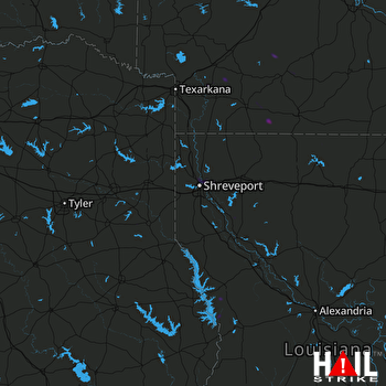 SHREVEPORT (KSHV) RADAR

