This weather event on August 23, 2024 includes:
2 states
14 counties,
17 cities,
and 68 zip codes.
There were total properties that were impacted and have possible damage.
States Impacted By Hail On August 23, 2024
Kansas
·
Nebraska
Counties Impacted By Hail On August 23, 2024
Barton, KS
·
Butler, KS
·
Cowley, KS
·
Ellsworth, KS
·
Harvey, KS
·
Lincoln, KS
·
Reno, KS
·
Rice, KS
·
Russell, KS
·
Sedgwick, KS
·
Stafford, KS
·
Saline, NE
·
Seward, NE
·
York, NE
Cities Impacted By Hail On August 23, 2024
Andover, KS
·
Augusta, KS
·
Derby, KS
·
Eastborough, KS
·
Friend, NE
·
Haven, KS
·
Haysville, KS
·
Hutchinson, KS
·
Maize, KS
·
McConnell AFB, KS
·
Mulvane, KS
·
Oaklawn-Sunview, KS
·
Park City, KS
·
Rose Hill, KS
·
Valley Center, KS
·
Wichita, KS
·
Willowbrook, KS
Zip Codes Impacted By Hail On August 23, 2024
67001
·
67002
·
67008
·
67010
·
67020
·
67023
·
67030
·
67037
·
67039
·
67052
·
67060
·
67074
·
67101
·
67108
·
67110
·
67133
·
67202
·
67203
·
67205
·
67206
·
67207
·
67208
·
67209
·
67210
·
67211
·
67212
·
67213
·
67214
·
67215
·
67216
·
67217
·
67218
·
67219
·
67227
·
67230
·
67232
·
67235
·
67439
·
67455
·
67481
·
67490
·
67501
·
67502
·
67510
·
67512
·
67526
·
67530
·
67543
·
67544
·
67545
·
67561
·
67566
·
67568
·
67570
·
67576
·
67578
·
67579
·
67581
·
67626
·
67634
·
67648
·
67665
·
68313
·
68460
·
67072
·
67204
·
67573
·
68359
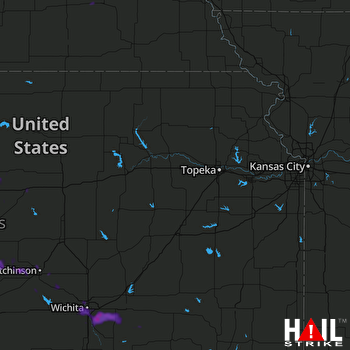 TOPEKA (KTWX) RADAR

