This weather event on August 18, 2024 includes:
1 states
21 counties,
22 cities,
and 73 zip codes.
There were 990 total properties that were impacted and have possible damage.
States Impacted By Hail On August 18, 2024
Montana
Counties Impacted By Hail On August 18, 2024
Blaine, MT
·
Cascade, MT
·
Chouteau, MT
·
Deer Lodge, MT
·
Fergus, MT
·
Flathead, MT
·
Glacier, MT
·
Granite, MT
·
Hill, MT
·
Judith Basin, MT
·
Lewis and Clark, MT
·
Liberty, MT
·
Meagher, MT
·
Missoula, MT
·
Petroleum, MT
·
Phillips, MT
·
Pondera, MT
·
Powell, MT
·
Ravalli, MT
·
Teton, MT
·
Toole, MT
Cities Impacted By Hail On August 18, 2024
Anaconda-Deer Lodge County, MT
·
Augusta, MT
·
Avon, MT
·
Azure, MT
·
Cascade, MT
·
Dupuyer, MT
·
Evaro, MT
·
Florence, MT
·
Fort Benton, MT
·
Geraldine, MT
·
Geyser, MT
·
Gibson Flats, MT
·
Great Falls, MT
·
Hays, MT
·
Heart Butte, MT
·
Highwood, MT
·
Lodge Pole, MT
·
Loma, MT
·
Malmstrom AFB, MT
·
Sand Coulee, MT
·
Sangrey, MT
·
Stockett, MT
Zip Codes Impacted By Hail On August 18, 2024
59087
·
59405
·
59410
·
59412
·
59416
·
59417
·
59419
·
59420
·
59422
·
59432
·
59433
·
59434
·
59436
·
59440
·
59442
·
59443
·
59444
·
59446
·
59447
·
59448
·
59450
·
59452
·
59456
·
59460
·
59461
·
59463
·
59467
·
59468
·
59469
·
59472
·
59474
·
59479
·
59480
·
59486
·
59489
·
59501
·
59520
·
59521
·
59522
·
59523
·
59524
·
59525
·
59526
·
59527
·
59538
·
59540
·
59545
·
59546
·
59633
·
59639
·
59645
·
59648
·
59711
·
59713
·
59722
·
59731
·
59733
·
59808
·
59821
·
59823
·
59825
·
59832
·
59833
·
59843
·
59854
·
59858
·
59870
·
59919
·
59936
·
59053
·
59404
·
59421
·
59535
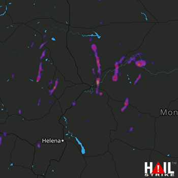 GREAT FALLS (KTFX) RADAR

