This weather event on August 18, 2024 includes:
2 states
17 counties,
25 cities,
and 78 zip codes.
There were 449 total properties that were impacted and have possible damage.
States Impacted By Hail On August 18, 2024
Kansas
·
Nebraska
Counties Impacted By Hail On August 18, 2024
Clay, KS
·
Cloud, KS
·
Geary, KS
·
Jewell, KS
·
Pottawatomie, KS
·
Republic, KS
·
Riley, KS
·
Wabaunsee, KS
·
Washington, KS
·
Clay, NE
·
Fillmore, NE
·
Jefferson, NE
·
Nuckolls, NE
·
Saline, NE
·
Thayer, NE
·
Webster, NE
·
York, NE
Cities Impacted By Hail On August 18, 2024
Chester, NE
·
Clay Center, KS
·
Clifton, KS
·
Clyde, KS
·
Exeter, NE
·
Fort Riley, KS
·
Geneva, NE
·
Grafton, NE
·
Junction City, KS
·
Lawrence, NE
·
McCool Junction, NE
·
McFarland, KS
·
Milford, KS
·
Morganville, KS
·
Munden, KS
·
Nelson, NE
·
Nora, NE
·
Ohiowa, NE
·
Paxico, KS
·
Ruskin, NE
·
St. George, KS
·
Vining, KS
·
Wakefield, KS
·
Western, NE
·
York, NE
Zip Codes Impacted By Hail On August 18, 2024
66401
·
66423
·
66431
·
66441
·
66442
·
66501
·
66502
·
66507
·
66514
·
66520
·
66526
·
66531
·
66535
·
66547
·
66549
·
66554
·
66901
·
66930
·
66933
·
66935
·
66937
·
66938
·
66939
·
66940
·
66945
·
66946
·
66955
·
66958
·
66959
·
66960
·
66964
·
66966
·
66968
·
67432
·
67447
·
67468
·
67487
·
68303
·
68322
·
68325
·
68327
·
68338
·
68340
·
68343
·
68351
·
68352
·
68354
·
68359
·
68365
·
68370
·
68375
·
68377
·
68401
·
68406
·
68416
·
68424
·
68436
·
68445
·
68453
·
68460
·
68464
·
68465
·
68467
·
68930
·
68934
·
68935
·
68938
·
68942
·
68943
·
68957
·
68961
·
68964
·
68974
·
68978
·
68444
·
68361
·
68335
·
66449
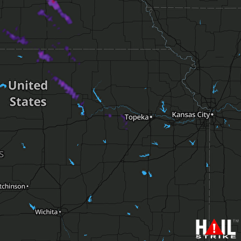 TOPEKA (KTWX) RADAR

