This weather event on August 14, 2024 includes:
3 states
14 counties,
14 cities,
and 72 zip codes.
There were 1387 total properties that were impacted and have possible damage.
States Impacted By Hail On August 14, 2024
Massachusetts
·
New York
·
Vermont
Counties Impacted By Hail On August 14, 2024
Berkshire, MA
·
Franklin, MA
·
Hampshire, MA
·
Essex, NY
·
Fulton, NY
·
Hamilton, NY
·
Herkimer, NY
·
Montgomery, NY
·
Saratoga, NY
·
Schenectady, NY
·
Warren, NY
·
Chittenden, VT
·
Franklin, VT
·
Grand Isle, VT
Cities Impacted By Hail On August 14, 2024
Chestertown, NY
·
Dolgeville, NY
·
East Glenville, NY
·
Galway, NY
·
Lake Luzerne, NY
·
Little Falls, NY
·
Milton, VT
·
Niskayuna, NY
·
North Adams, MA
·
Pottersville, NY
·
Schenectady, NY
·
Scotia, NY
·
St. Albans, VT
·
Warrensburg, NY
Zip Codes Impacted By Hail On August 14, 2024
12804
·
1012
·
1026
·
1084
·
1098
·
1235
·
1350
·
5440
·
5446
·
5454
·
5455
·
5458
·
5468
·
5474
·
5478
·
5483
·
5486
·
5488
·
12008
·
12010
·
12019
·
12020
·
12025
·
12027
·
12032
·
12065
·
12074
·
12078
·
12086
·
12095
·
12117
·
12134
·
12139
·
12148
·
12190
·
12302
·
12304
·
12305
·
12306
·
12307
·
12308
·
12309
·
12808
·
12810
·
12814
·
12815
·
12817
·
12824
·
12835
·
12846
·
12847
·
12850
·
12851
·
12855
·
12857
·
12860
·
12863
·
12870
·
12878
·
12885
·
12928
·
12960
·
12961
·
12998
·
13329
·
13339
·
13365
·
13407
·
13452
·
13454
·
13470
·
1247
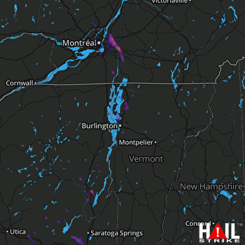 BURLINGTON (KCXX) RADAR

