This weather event on July 17, 2024 includes:
4 states
22 counties,
10 cities,
and 56 zip codes.
There were 167 total properties that were impacted and have possible damage.
States Impacted By Hail On July 17, 2024
Colorado
·
Kansas
·
Nebraska
·
South Dakota
Counties Impacted By Hail On July 17, 2024
Logan, CO
·
Phillips, CO
·
Sedgwick, CO
·
Cheyenne, KS
·
Rawlins, KS
·
Arthur, NE
·
Box Butte, NE
·
Chase, NE
·
Cherry, NE
·
Cheyenne, NE
·
Dawes, NE
·
Deuel, NE
·
Dundy, NE
·
Garden, NE
·
Grant, NE
·
Hitchcock, NE
·
Keith, NE
·
Morrill, NE
·
Perkins, NE
·
Sheridan, NE
·
Bennett, SD
·
Oglala Lakota, SD
Cities Impacted By Hail On July 17, 2024
Amherst, CO
·
Chappell, NE
·
Hay Springs, NE
·
Imperial, NE
·
Manderson-White Horse Creek, SD
·
Max, NE
·
Ogallala, NE
·
Ovid, CO
·
Rushville, NE
·
Sunol, NE
Zip Codes Impacted By Hail On July 17, 2024
57551
·
57716
·
57756
·
57764
·
57770
·
57772
·
57794
·
67739
·
67744
·
67745
·
69021
·
69023
·
69030
·
69033
·
69037
·
69041
·
69043
·
69044
·
69045
·
69121
·
69122
·
69127
·
69129
·
69131
·
69140
·
69146
·
69148
·
69149
·
69150
·
69153
·
69154
·
69156
·
69162
·
69168
·
69218
·
69331
·
69333
·
69334
·
69336
·
69337
·
69343
·
69347
·
69348
·
69351
·
69360
·
80721
·
80728
·
80731
·
80734
·
80737
·
80744
·
80749
·
80758
·
69301
·
69147
·
69141
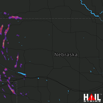 NORTH PLATTE (KLNX) RADAR

