This weather event on July 15, 2024 includes:
3 states
29 counties,
8 cities,
and 64 zip codes.
There were 100 total properties that were impacted and have possible damage.
States Impacted By Hail On July 15, 2024
Colorado
·
Kansas
·
Nebraska
Counties Impacted By Hail On July 15, 2024
Bent, CO
·
Cheyenne, CO
·
Kiowa, CO
·
Logan, CO
·
Phillips, CO
·
Prowers, CO
·
Cheyenne, KS
·
Ellis, KS
·
Finney, KS
·
Gove, KS
·
Graham, KS
·
Greeley, KS
·
Hamilton, KS
·
Kearny, KS
·
Lane, KS
·
Logan, KS
·
Ness, KS
·
Norton, KS
·
Osborne, KS
·
Phillips, KS
·
Rooks, KS
·
Russell, KS
·
Sherman, KS
·
Stanton, KS
·
Thomas, KS
·
Trego, KS
·
Wallace, KS
·
Wichita, KS
·
Chase, NE
Cities Impacted By Hail On July 15, 2024
Catharine, KS
·
Greeley County unified government (balance), KS
·
Hays, KS
·
Munjor, KS
·
Ransom, KS
·
Russell Springs, KS
·
Utica, KS
·
Weskan, KS
Zip Codes Impacted By Hail On July 15, 2024
67518
·
67521
·
67556
·
67560
·
67572
·
67584
·
67601
·
67623
·
67631
·
67637
·
67639
·
67640
·
67644
·
67645
·
67650
·
67651
·
67656
·
67661
·
67663
·
67665
·
67669
·
67671
·
67672
·
67674
·
67675
·
67731
·
67733
·
67735
·
67736
·
67737
·
67738
·
67748
·
67752
·
67758
·
67761
·
67762
·
67764
·
67838
·
67839
·
67846
·
67850
·
67855
·
67857
·
67860
·
67861
·
67862
·
67878
·
67879
·
69023
·
69033
·
69168
·
80726
·
80734
·
80802
·
81036
·
81044
·
81047
·
81052
·
81054
·
81071
·
81092
·
67515
·
67621
·
67851
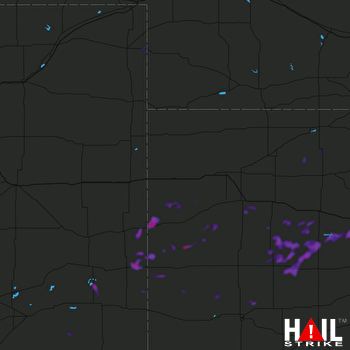 GOODLAND (KGLD) RADAR

