This weather event on July 11, 2024 includes:
2 states
17 counties,
17 cities,
and 59 zip codes.
There were 139 total properties that were impacted and have possible damage.
States Impacted By Hail On July 11, 2024
Kansas
·
Missouri
Counties Impacted By Hail On July 11, 2024
Atchison, KS
·
Brown, KS
·
Coffey, KS
·
Doniphan, KS
·
Leavenworth, KS
·
Lyon, KS
·
Nemaha, KS
·
Osage, KS
·
Buchanan, MO
·
Caldwell, MO
·
Carroll, MO
·
Clay, MO
·
Clinton, MO
·
Lafayette, MO
·
Platte, MO
·
Ray, MO
·
Saline, MO
Cities Impacted By Hail On July 11, 2024
Elwood, KS
·
Excelsior Springs, MO
·
Ferrelview, MO
·
Gladstone, MO
·
Hiawatha, KS
·
Highland, KS
·
Kansas City, MO
·
Lancaster, KS
·
Leavenworth, KS
·
Lebo, KS
·
Platte City, MO
·
Ridgely, MO
·
Sabetha, KS
·
Smithville, MO
·
Troy, KS
·
Wathena, KS
·
Weston, MO
Zip Codes Impacted By Hail On July 11, 2024
64001
·
64018
·
64021
·
64022
·
64024
·
64048
·
64060
·
64077
·
64079
·
64084
·
64085
·
64089
·
64098
·
64118
·
64119
·
64153
·
64154
·
64155
·
64156
·
64163
·
64164
·
64165
·
64429
·
64439
·
64444
·
64465
·
64484
·
64492
·
64493
·
64503
·
64504
·
64668
·
64671
·
65340
·
65351
·
66002
·
66016
·
66020
·
66023
·
66024
·
66027
·
66035
·
66041
·
66048
·
66058
·
66060
·
66087
·
66090
·
66424
·
66434
·
66439
·
66515
·
66532
·
66534
·
66801
·
66830
·
66833
·
66856
·
66868
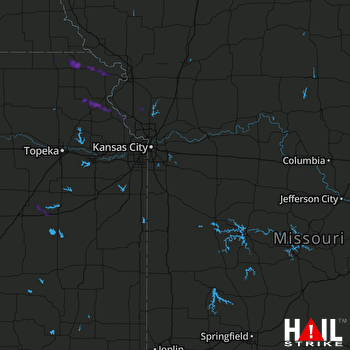 KANSAS CITY (KEAX) RADAR

