This weather event on July 2, 2024 includes:
3 states
27 counties,
18 cities,
and 70 zip codes.
There were 1813 total properties that were impacted and have possible damage.
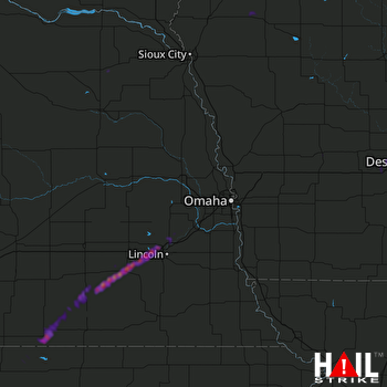 OMAHA (KOAX) RADAR
States Impacted By Hail On July 2, 2024
Iowa
·
Kansas
·
Nebraska
Counties Impacted By Hail On July 2, 2024
Adair, IA
·
Audubon, IA
·
Boone, IA
·
Carroll, IA
·
Cherokee, IA
·
Dallas, IA
·
Fremont, IA
·
Guthrie, IA
·
Hamilton, IA
·
Madison, IA
·
Page, IA
·
Plymouth, IA
·
Pottawattamie, IA
·
Webster, IA
·
Jewell, KS
·
Cass, NE
·
Cedar, NE
·
Clay, NE
·
Fillmore, NE
·
Lancaster, NE
·
Nuckolls, NE
·
Pierce, NE
·
Saline, NE
·
Sarpy, NE
·
Saunders, NE
·
Seward, NE
·
Thayer, NE
Cities Impacted By Hail On July 2, 2024
Burr Oak, KS
·
Davenport, NE
·
Dexter, IA
·
Diamondhead Lake, IA
·
Dorchester, NE
·
Friend, NE
·
Geneva, NE
·
Lincoln, NE
·
Linden, IA
·
Louisville, NE
·
Nora, NE
·
Oak, NE
·
Pleasant Dale, NE
·
Randolph, NE
·
Redfield, IA
·
Shickley, NE
·
Strang, NE
·
Stratford, IA
Zip Codes Impacted By Hail On July 2, 2024
50003
·
50025
·
50036
·
50058
·
50066
·
50070
·
50072
·
50076
·
50146
·
50216
·
50220
·
50233
·
50249
·
51012
·
51014
·
51024
·
51035
·
51037
·
51401
·
51443
·
51503
·
51601
·
51638
·
51639
·
66936
·
68003
·
68017
·
68028
·
68037
·
68046
·
68058
·
68059
·
68322
·
68326
·
68333
·
68335
·
68336
·
68339
·
68343
·
68351
·
68354
·
68359
·
68361
·
68366
·
68405
·
68406
·
68407
·
68416
·
68423
·
68428
·
68436
·
68452
·
68462
·
68504
·
68514
·
68517
·
68521
·
68522
·
68524
·
68528
·
68532
·
68771
·
68935
·
68961
·
68964
·
68978
·
68531
·
68444
·
68402
·
50117

