This weather event on June 25, 2024 includes:
2 states
27 counties,
23 cities,
and 79 zip codes.
There were 612 total properties that were impacted and have possible damage.
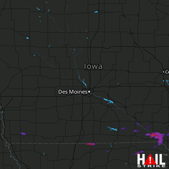 DES MOINES (KDMX) RADAR
States Impacted By Hail On June 25, 2024
Iowa
·
Missouri
Counties Impacted By Hail On June 25, 2024
Adams, IA
·
Appanoose, IA
·
Davis, IA
·
Decatur, IA
·
Des Moines, IA
·
Fremont, IA
·
Henry, IA
·
Jefferson, IA
·
Lee, IA
·
Monroe, IA
·
Montgomery, IA
·
Page, IA
·
Pottawattamie, IA
·
Van Buren, IA
·
Wapello, IA
·
Wayne, IA
·
Adair, MO
·
Clark, MO
·
Knox, MO
·
Linn, MO
·
Livingston, MO
·
Macon, MO
·
Mercer, MO
·
Putnam, MO
·
Schuyler, MO
·
Scotland, MO
·
Sullivan, MO
Cities Impacted By Hail On June 25, 2024
Bonaparte, IA
·
Chillicothe, MO
·
Corning, IA
·
Danville, IA
·
Denmark, IA
·
Elmer, MO
·
Essex, IA
·
Farmington, IA
·
Floris, IA
·
Fort Madison, IA
·
Franklin, IA
·
Keosauqua, IA
·
Lineville, IA
·
Moravia, IA
·
New London, IA
·
Ottumwa, IA
·
Pulaski, IA
·
Queen City, MO
·
Red Oak, IA
·
Shenandoah, IA
·
South Lineville, MO
·
St. Paul, IA
·
West Point, IA
Zip Codes Impacted By Hail On June 25, 2024
50841
·
50864
·
51525
·
51533
·
51541
·
51566
·
51601
·
51632
·
51638
·
51645
·
52501
·
52531
·
52533
·
52535
·
52536
·
52537
·
52544
·
52551
·
52552
·
52554
·
52556
·
52560
·
52565
·
52567
·
52569
·
52570
·
52571
·
52573
·
52584
·
52588
·
52594
·
52619
·
52620
·
52623
·
52624
·
52625
·
52626
·
52627
·
52630
·
52637
·
52640
·
52641
·
52645
·
52649
·
52650
·
52651
·
52656
·
52658
·
52660
·
63432
·
63445
·
63453
·
63460
·
63465
·
63530
·
63536
·
63538
·
63539
·
63546
·
63549
·
63555
·
63557
·
63560
·
63561
·
63565
·
63566
·
64601
·
64632
·
64653
·
64655
·
64659
·
64661
·
64674
·
64688
·
50065
·
50147
·
51535
·
52530
·
52657

