This weather event on June 17, 2024 includes:
4 states
24 counties,
11 cities,
and 61 zip codes.
There were total properties that were impacted and have possible damage.
States Impacted By Hail On June 17, 2024
Kentucky
·
Tennessee
·
Virginia
·
West Virginia
Counties Impacted By Hail On June 17, 2024
Bath, KY
·
Breathitt, KY
·
Clay, KY
·
Elliott, KY
·
Estill, KY
·
Fleming, KY
·
Floyd, KY
·
Knott, KY
·
Laurel, KY
·
Lee, KY
·
Leslie, KY
·
Magoffin, KY
·
Martin, KY
·
Menifee, KY
·
Morgan, KY
·
Perry, KY
·
Pike, KY
·
Powell, KY
·
Rowan, KY
·
Wolfe, KY
·
Johnson, TN
·
Buchanan, VA
·
Logan, WV
·
Mingo, WV
Cities Impacted By Hail On June 17, 2024
Beattyville, KY
·
Campton, KY
·
Delbarton, WV
·
Frenchburg, KY
·
Gilbert, WV
·
Gilbert Creek, WV
·
Justice, WV
·
Kistler, WV
·
Mallory, WV
·
Matewan, WV
·
Red Jacket, WV
Zip Codes Impacted By Hail On June 17, 2024
24620
·
24846
·
24851
·
25606
·
25608
·
25617
·
25621
·
25628
·
25634
·
25635
·
25638
·
25651
·
25661
·
25670
·
25672
·
25678
·
25688
·
25690
·
25692
·
25696
·
37683
·
40322
·
40351
·
40358
·
40371
·
40376
·
40380
·
40387
·
40472
·
40741
·
40827
·
40874
·
40913
·
40962
·
40979
·
41049
·
41171
·
41231
·
41250
·
41301
·
41311
·
41339
·
41360
·
41365
·
41385
·
41464
·
41465
·
41472
·
41544
·
41568
·
41572
·
41607
·
41616
·
41632
·
41640
·
41653
·
41701
·
41723
·
41749
·
41776
·
41862
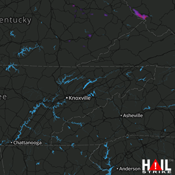 KNOXVILLE (KMRX) RADAR

