This weather event on June 17, 2024 includes:
2 states
20 counties,
26 cities,
and 69 zip codes.
There were 212 total properties that were impacted and have possible damage.
States Impacted By Hail On June 17, 2024
Iowa
·
Minnesota
Counties Impacted By Hail On June 17, 2024
Cerro Gordo, IA
·
Cherokee, IA
·
Clay, IA
·
Dickinson, IA
·
Emmet, IA
·
Floyd, IA
·
Hancock, IA
·
Howard, IA
·
Kossuth, IA
·
O'Brien, IA
·
Osceola, IA
·
Palo Alto, IA
·
Plymouth, IA
·
Winnebago, IA
·
Winneshiek, IA
·
Faribault, MN
·
Fillmore, MN
·
Freeborn, MN
·
Jackson, MN
·
Mower, MN
Cities Impacted By Hail On June 17, 2024
Alden, MN
·
Calumet, IA
·
Chester, IA
·
Clear Lake, IA
·
Cresco, IA
·
Dickens, IA
·
Greenville, IA
·
Le Roy, MN
·
Lime Springs, IA
·
Ostrander, MN
·
Primghar, IA
·
Rake, IA
·
Remsen, IA
·
Rockford, IA
·
Rossie, IA
·
Royal, IA
·
Ruthven, IA
·
Sanborn, IA
·
Sexton, IA
·
Spencer, IA
·
St. Benedict, IA
·
Sutherland, IA
·
Ventura, IA
·
Walters, MN
·
Wesley, IA
·
West Bend, IA
Zip Codes Impacted By Hail On June 17, 2024
50401
·
50424
·
50428
·
50430
·
50438
·
50458
·
50465
·
50466
·
50469
·
50478
·
50482
·
50483
·
50511
·
50536
·
50558
·
50560
·
50570
·
50585
·
50597
·
50598
·
50628
·
51009
·
51012
·
51014
·
51022
·
51029
·
51031
·
51033
·
51035
·
51037
·
51046
·
51047
·
51050
·
51058
·
51201
·
51231
·
51245
·
51248
·
51301
·
51333
·
51334
·
51338
·
51342
·
51343
·
51346
·
51347
·
51357
·
51358
·
51360
·
51364
·
51365
·
52136
·
52155
·
55939
·
55951
·
55961
·
55975
·
56007
·
56009
·
56014
·
56027
·
56033
·
56051
·
56097
·
56143
·
56150
·
52134
·
51345
·
50468
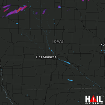 DES MOINES (KDMX) RADAR

