This weather event on May 29, 2024 includes:
3 states
26 counties,
12 cities,
and 54 zip codes.
There were 2443 total properties that were impacted and have possible damage.
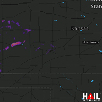 DODGE CITY (KDDC) RADAR
States Impacted By Hail On May 29, 2024
Colorado
·
Kansas
·
Oklahoma
Counties Impacted By Hail On May 29, 2024
Baca, CO
·
Cheyenne, CO
·
Kiowa, CO
·
Prowers, CO
·
Clark, KS
·
Decatur, KS
·
Edwards, KS
·
Finney, KS
·
Ford, KS
·
Gray, KS
·
Greeley, KS
·
Hamilton, KS
·
Hodgeman, KS
·
Kearny, KS
·
Kiowa, KS
·
Logan, KS
·
Meade, KS
·
Norton, KS
·
Scott, KS
·
Stafford, KS
·
Wallace, KS
·
Wichita, KS
·
Cimarron, OK
·
Ellis, OK
·
Harper, OK
·
Texas, OK
Cities Impacted By Hail On May 29, 2024
Dodge City, KS
·
Fowler, KS
·
Greeley County unified government (balance), KS
·
Hooker, OK
·
Jetmore, KS
·
Lamar, CO
·
Marienthal, KS
·
Scott City, KS
·
Spearville, KS
·
Syracuse, KS
·
Wilroads Gardens, KS
·
Wright, KS
Zip Codes Impacted By Hail On May 29, 2024
67054
·
67059
·
67109
·
67523
·
67547
·
67557
·
67563
·
67576
·
67629
·
67653
·
67758
·
67761
·
67762
·
67764
·
67801
·
67831
·
67834
·
67835
·
67838
·
67841
·
67842
·
67844
·
67846
·
67849
·
67851
·
67853
·
67857
·
67860
·
67861
·
67863
·
67868
·
67871
·
67876
·
67878
·
67879
·
67882
·
73832
·
73834
·
73933
·
73939
·
73945
·
73947
·
80802
·
80810
·
81029
·
81036
·
81041
·
81047
·
81052
·
81071
·
81084
·
81090
·
67854
·
67840

