This weather event on May 28, 2024 includes:
1 states
18 counties,
23 cities,
and 52 zip codes.
There were total properties that were impacted and have possible damage.
States Impacted By Hail On May 28, 2024
Florida
Counties Impacted By Hail On May 28, 2024
Brevard, FL
·
Broward, FL
·
Flagler, FL
·
Glades, FL
·
Hendry, FL
·
Highlands, FL
·
Indian River, FL
·
Lake, FL
·
Marion, FL
·
Martin, FL
·
Okeechobee, FL
·
Orange, FL
·
Osceola, FL
·
Palm Beach, FL
·
Putnam, FL
·
Seminole, FL
·
St. Lucie, FL
·
Volusia, FL
Cities Impacted By Hail On May 28, 2024
Altamonte Springs, FL
·
Astor, FL
·
Bunnell, FL
·
Canal Point, FL
·
Clewiston, FL
·
Conway, FL
·
Crescent City, FL
·
De Leon Springs, FL
·
Forest City, FL
·
Harlem, FL
·
Loxahatchee Groves, FL
·
Ormond Beach, FL
·
Ormond-by-the-Sea, FL
·
Pahokee, FL
·
Palm Beach Gardens, FL
·
Palm City, FL
·
Palm Coast, FL
·
Pierson, FL
·
Port St. Lucie, FL
·
South Bay, FL
·
The Acreage, FL
·
Wedgefield, FL
·
Wekiwa Springs, FL
Zip Codes Impacted By Hail On May 28, 2024
32176
·
32102
·
32112
·
32130
·
32134
·
32136
·
32139
·
32164
·
32174
·
32180
·
32703
·
32709
·
32712
·
32714
·
32720
·
32724
·
32757
·
32779
·
32812
·
32822
·
32827
·
32832
·
32833
·
32940
·
32966
·
33412
·
33418
·
33430
·
33438
·
33440
·
33470
·
33471
·
33476
·
33478
·
33493
·
33857
·
34705
·
34739
·
34744
·
34771
·
34773
·
34945
·
34953
·
34956
·
34972
·
34974
·
34984
·
34986
·
34987
·
34990
·
34997
·
32110
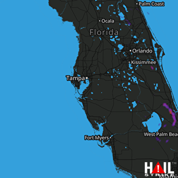 TAMPA (KTBW) RADAR

