This weather event on May 25, 2024 includes:
1 states
18 counties,
37 cities,
and 63 zip codes.
There were 2512 total properties that were impacted and have possible damage.
States Impacted By Hail On May 25, 2024
Florida
Counties Impacted By Hail On May 25, 2024
Brevard, FL
·
Broward, FL
·
Collier, FL
·
Flagler, FL
·
Glades, FL
·
Hendry, FL
·
Indian River, FL
·
Lake, FL
·
Martin, FL
·
Okeechobee, FL
·
Orange, FL
·
Osceola, FL
·
Palm Beach, FL
·
Polk, FL
·
Seminole, FL
·
St. Johns, FL
·
St. Lucie, FL
·
Volusia, FL
Cities Impacted By Hail On May 25, 2024
Bay Lake, FL
·
Belle Glade, FL
·
Buckhead Ridge, FL
·
Bunnell, FL
·
Cocoa, FL
·
DeLand, FL
·
DeLand Southwest, FL
·
Edgewater, FL
·
Fellsmere, FL
·
Geneva, FL
·
Gifford, FL
·
Glencoe, FL
·
Horizon West, FL
·
Hutchinson Island South, FL
·
Jensen Beach, FL
·
Lake Kathryn, FL
·
Lake Mack-Forest Hills, FL
·
Merritt Island, FL
·
New Smyrna Beach, FL
·
North DeLand, FL
·
Orange City, FL
·
Pahokee, FL
·
Palm Beach Gardens, FL
·
Pine Lakes, FL
·
Poinciana, FL
·
Ponce Inlet, FL
·
Port Orange, FL
·
Port St. John, FL
·
Port St. Lucie, FL
·
Samsula-Spruce Creek, FL
·
Sharpes, FL
·
South Bay, FL
·
The Acreage, FL
·
Titusville, FL
·
Vero Beach, FL
·
West DeLand, FL
·
Winter Beach, FL
Zip Codes Impacted By Hail On May 25, 2024
32110
·
32124
·
32127
·
32128
·
32132
·
32145
·
32168
·
32169
·
32709
·
32720
·
32724
·
32732
·
32736
·
32754
·
32763
·
32767
·
32780
·
32796
·
32830
·
32836
·
32926
·
32927
·
32934
·
32940
·
32948
·
32952
·
32953
·
32960
·
32966
·
32967
·
33412
·
33430
·
33438
·
33440
·
33455
·
33470
·
33478
·
33493
·
33825
·
33855
·
33898
·
34141
·
34739
·
34758
·
34759
·
34771
·
34772
·
34773
·
34786
·
34945
·
34952
·
34956
·
34957
·
34972
·
34974
·
34983
·
34984
·
34987
·
34990
·
34997
·
34953
·
34746
·
33476
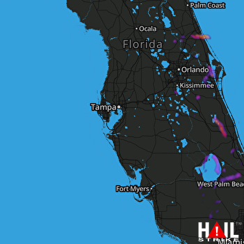 TAMPA (KTBW) RADAR

