This weather event on May 19, 2024 includes:
3 states
20 counties,
28 cities,
and 85 zip codes.
There were 12952 total properties that were impacted and have possible damage.
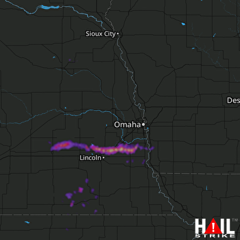 OMAHA (KOAX) RADAR
States Impacted By Hail On May 19, 2024
Iowa
·
Kansas
·
Nebraska
Counties Impacted By Hail On May 19, 2024
Fremont, IA
·
Mills, IA
·
Montgomery, IA
·
Cloud, KS
·
Republic, KS
·
Washington, KS
·
Butler, NE
·
Cass, NE
·
Gage, NE
·
Jefferson, NE
·
Lancaster, NE
·
Otoe, NE
·
Polk, NE
·
Saline, NE
·
Sarpy, NE
·
Saunders, NE
·
Seward, NE
·
Thayer, NE
·
Wayne, NE
·
York, NE
Cities Impacted By Hail On May 19, 2024
Alvo, NE
·
Avoca, NE
·
Beatrice, NE
·
Bee, NE
·
Benedict, NE
·
Daykin, NE
·
Garland, NE
·
Greenwood, NE
·
Gresham, NE
·
Haddam, KS
·
Harbine, NE
·
Jansen, NE
·
Lincoln, NE
·
Louisville, NE
·
Malcolm, NE
·
Manley, NE
·
Murdock, NE
·
Murray, NE
·
Raymond, NE
·
Reynolds, NE
·
Seward, NE
·
South Bend, NE
·
Staplehurst, NE
·
Swanton, NE
·
Thayer, NE
·
Waverly, NE
·
Weeping Water, NE
·
Wilber, NE
Zip Codes Impacted By Hail On May 19, 2024
50864
·
51534
·
51561
·
51573
·
51649
·
51654
·
66901
·
66933
·
66935
·
66940
·
66943
·
66944
·
66955
·
66959
·
66960
·
68003
·
68016
·
68028
·
68037
·
68048
·
68058
·
68059
·
68065
·
68303
·
68304
·
68307
·
68310
·
68314
·
68315
·
68316
·
68319
·
68322
·
68336
·
68338
·
68341
·
68342
·
68349
·
68352
·
68360
·
68366
·
68367
·
68370
·
68375
·
68377
·
68402
·
68407
·
68409
·
68410
·
68413
·
68415
·
68417
·
68423
·
68424
·
68428
·
68434
·
68439
·
68445
·
68446
·
68454
·
68455
·
68456
·
68460
·
68462
·
68463
·
68464
·
68465
·
68467
·
68504
·
68505
·
68507
·
68514
·
68517
·
68521
·
68524
·
68527
·
68531
·
68654
·
68666
·
68667
·
68669
·
68740
·
68790
·
68403
·
68347
·
68346

