This weather event on May 14, 2024 includes:
3 states
31 counties,
8 cities,
and 63 zip codes.
There were 625 total properties that were impacted and have possible damage.
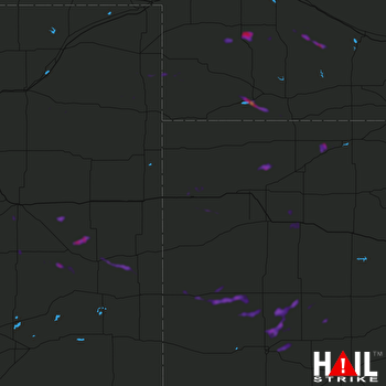 GOODLAND (KGLD) RADAR
States Impacted By Hail On May 14, 2024
Colorado
·
Kansas
·
Nebraska
Counties Impacted By Hail On May 14, 2024
Cheyenne, CO
·
Elbert, CO
·
Kit Carson, CO
·
Lincoln, CO
·
Phillips, CO
·
Washington, CO
·
Yuma, CO
·
Decatur, KS
·
Finney, KS
·
Gove, KS
·
Gray, KS
·
Greeley, KS
·
Hodgeman, KS
·
Lane, KS
·
Logan, KS
·
Ness, KS
·
Norton, KS
·
Rawlins, KS
·
Rooks, KS
·
Scott, KS
·
Sheridan, KS
·
Sherman, KS
·
Thomas, KS
·
Wichita, KS
·
Chase, NE
·
Frontier, NE
·
Hayes, NE
·
Hitchcock, NE
·
Lincoln, NE
·
Perkins, NE
·
Red Willow, NE
Cities Impacted By Hail On May 14, 2024
Clayton, KS
·
Greeley County unified government (balance), KS
·
Horace, KS
·
Marienthal, KS
·
Norcatur, KS
·
North Platte, NE
·
Trenton, NE
·
Tribune, KS
Zip Codes Impacted By Hail On May 14, 2024
67629
·
67653
·
67654
·
67663
·
67701
·
67730
·
67732
·
67734
·
67735
·
67737
·
67738
·
67740
·
67748
·
67749
·
67753
·
67764
·
67835
·
67839
·
67846
·
67851
·
67854
·
67861
·
67863
·
67871
·
67879
·
69001
·
69023
·
69024
·
69025
·
69028
·
69029
·
69030
·
69032
·
69039
·
69040
·
69043
·
69044
·
69101
·
69123
·
69132
·
69134
·
69151
·
69169
·
80720
·
80727
·
80734
·
80758
·
80802
·
80807
·
80810
·
80815
·
80821
·
80823
·
80825
·
80828
·
80836
·
80862
·
81063
·
67560
·
67733
·
69170
·
80804
·
80833

