This weather event on May 9, 2024 includes:
1 states
19 counties,
18 cities,
and 57 zip codes.
There were 497 total properties that were impacted and have possible damage.
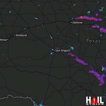 SAN ANGELO (KSJT) RADAR
States Impacted By Hail On May 9, 2024
Texas
Counties Impacted By Hail On May 9, 2024
Blanco, TX
·
Burnet, TX
·
Callahan, TX
·
Coke, TX
·
Comanche, TX
·
Concho, TX
·
Eastland, TX
·
Erath, TX
·
Gillespie, TX
·
Hamilton, TX
·
Lampasas, TX
·
Llano, TX
·
Mason, TX
·
McCulloch, TX
·
Palo Pinto, TX
·
San Saba, TX
·
Shackelford, TX
·
Stephens, TX
·
Tom Green, TX
Cities Impacted By Hail On May 9, 2024
Brady, TX
·
Burnet, TX
·
Carbon, TX
·
Cottonwood Shores, TX
·
De Leon, TX
·
Dublin, TX
·
Eden, TX
·
Granite Shoals, TX
·
Horseshoe Bay, TX
·
Johnson City, TX
·
Lampasas, TX
·
Mingus, TX
·
Ranger, TX
·
Round Mountain, TX
·
Stephenville, TX
·
Stonewall, TX
·
Strawn, TX
·
Sunrise Beach Village, TX
Zip Codes Impacted By Hail On May 9, 2024
76401
·
76424
·
76429
·
76430
·
76435
·
76436
·
76437
·
76443
·
76444
·
76445
·
76446
·
76448
·
76454
·
76457
·
76463
·
76464
·
76470
·
76471
·
76475
·
76539
·
76550
·
76820
·
76824
·
76825
·
76831
·
76832
·
76837
·
76842
·
76852
·
76853
·
76856
·
76858
·
76861
·
76866
·
76869
·
76877
·
76885
·
76887
·
76901
·
76903
·
76953
·
78607
·
78611
·
78624
·
78635
·
78636
·
78639
·
78643
·
78654
·
78657
·
78663
·
78671
·
78675
·
79504
·
79601
·
76862
·
76905

