This weather event on May 9, 2024 includes:
2 states
21 counties,
15 cities,
and 49 zip codes.
There were 3977 total properties that were impacted and have possible damage.
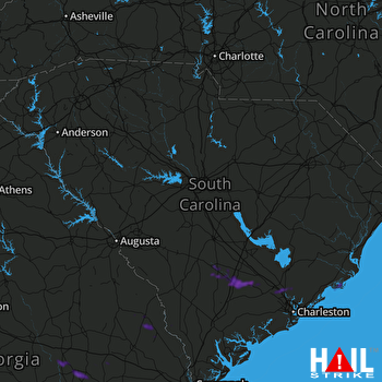 COLUMBIA (KCAE) RADAR
States Impacted By Hail On May 9, 2024
Georgia
·
South Carolina
Counties Impacted By Hail On May 9, 2024
Bryan, GA
·
Bulloch, GA
·
Candler, GA
·
Emanuel, GA
·
Evans, GA
·
Jenkins, GA
·
Liberty, GA
·
Long, GA
·
Montgomery, GA
·
Screven, GA
·
Tattnall, GA
·
Toombs, GA
·
Treutlen, GA
·
Wheeler, GA
·
Bamberg, SC
·
Berkeley, SC
·
Charleston, SC
·
Colleton, SC
·
Dorchester, SC
·
Hampton, SC
·
Orangeburg, SC
Cities Impacted By Hail On May 9, 2024
Awendaw, SC
·
Goose Creek, SC
·
Higgston, GA
·
Hollywood, SC
·
Ladson, SC
·
Lincolnville, SC
·
Lyons, GA
·
Meggett, SC
·
Mendes, GA
·
Richmond Hill, GA
·
Santa Claus, GA
·
Summerville, SC
·
Sylvania, GA
·
Tarrytown, GA
·
Vidalia, GA
Zip Codes Impacted By Hail On May 9, 2024
29003
·
29406
·
29412
·
29423
·
29426
·
29429
·
29432
·
29435
·
29437
·
29445
·
29449
·
29450
·
29455
·
29456
·
29458
·
29461
·
29471
·
29472
·
29474
·
29475
·
29477
·
29481
·
29485
·
29487
·
29488
·
29492
·
29922
·
29945
·
30410
·
30417
·
30420
·
30421
·
30427
·
30428
·
30436
·
30439
·
30442
·
30445
·
30446
·
30449
·
30452
·
30453
·
30455
·
30457
·
30467
·
30470
·
30474
·
31309
·
31324

