This weather event on May 9, 2024 includes:
2 states
25 counties,
17 cities,
and 57 zip codes.
There were 1160 total properties that were impacted and have possible damage.
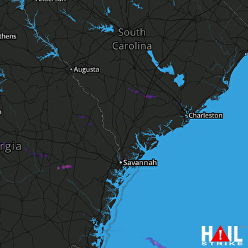 CHARLESTON (KCLX) RADAR
States Impacted By Hail On May 9, 2024
Georgia
·
South Carolina
Counties Impacted By Hail On May 9, 2024
Bacon, GA
·
Brantley, GA
·
Burke, GA
·
Dodge, GA
·
Glynn, GA
·
Jenkins, GA
·
Laurens, GA
·
Long, GA
·
Montgomery, GA
·
Pierce, GA
·
Screven, GA
·
Tattnall, GA
·
Toombs, GA
·
Treutlen, GA
·
Wayne, GA
·
Wheeler, GA
·
Bamberg, SC
·
Beaufort, SC
·
Berkeley, SC
·
Charleston, SC
·
Colleton, SC
·
Dorchester, SC
·
Hampton, SC
·
Jasper, SC
·
Orangeburg, SC
Cities Impacted By Hail On May 9, 2024
Ailey, GA
·
Chester, GA
·
Furman, SC
·
Glenwood, GA
·
Goose Creek, SC
·
Higgston, GA
·
Ladson, SC
·
Lincolnville, SC
·
Mendes, GA
·
Millen, GA
·
Mount Vernon, GA
·
Reidsville, GA
·
Scotia, SC
·
Summerville, SC
·
Sylvania, GA
·
Vidalia, GA
·
Yemassee, SC
Zip Codes Impacted By Hail On May 9, 2024
29003
·
29133
·
29406
·
29420
·
29423
·
29426
·
29432
·
29435
·
29437
·
29445
·
29456
·
29471
·
29472
·
29474
·
29477
·
29481
·
29485
·
29488
·
29916
·
29918
·
29921
·
29922
·
29934
·
29936
·
29939
·
29943
·
29944
·
29945
·
30410
·
30421
·
30427
·
30428
·
30441
·
30442
·
30445
·
30446
·
30449
·
30453
·
30455
·
30457
·
30467
·
30473
·
30474
·
31009
·
31012
·
31014
·
31019
·
31021
·
31023
·
31075
·
31316
·
31518
·
31523
·
31543
·
31551
·
31560
·
30436

