This weather event on May 8, 2024 includes:
2 states
22 counties,
16 cities,
and 58 zip codes.
There were 3416 total properties that were impacted and have possible damage.
States Impacted By Hail On May 8, 2024
North Carolina
·
Virginia
Counties Impacted By Hail On May 8, 2024
Craven, NC
·
Duplin, NC
·
Jones, NC
·
Lenoir, NC
·
Onslow, NC
·
Accomack, VA
·
Amelia, VA
·
Brunswick, VA
·
Charlotte, VA
·
Chesapeake, VA
·
Dinwiddie, VA
·
Halifax, VA
·
Isle of Wight, VA
·
Lunenburg, VA
·
Northampton, VA
·
Nottoway, VA
·
Pittsylvania, VA
·
Prince George, VA
·
Suffolk, VA
·
Surry, VA
·
Sussex, VA
·
Virginia Beach, VA
Cities Impacted By Hail On May 8, 2024
Chatham, VA
·
Chesapeake, VA
·
Dendron, VA
·
Drakes Branch, VA
·
Jackson Heights, NC
·
Kenbridge, VA
·
Keysville, VA
·
Lunenburg, VA
·
Pollocksville, NC
·
Potters Hill, NC
·
Suffolk, VA
·
Templeton, VA
·
Victoria, VA
·
Virginia Beach, VA
·
Wakefield, VA
·
Waverly, VA
Zip Codes Impacted By Hail On May 8, 2024
23083
·
23306
·
23320
·
23321
·
23323
·
23350
·
23398
·
23405
·
23430
·
23435
·
23456
·
23457
·
23805
·
23821
·
23824
·
23830
·
23839
·
23840
·
23841
·
23842
·
23846
·
23850
·
23872
·
23885
·
23888
·
23890
·
23894
·
23922
·
23923
·
23930
·
23937
·
23938
·
23944
·
23947
·
23952
·
23962
·
23967
·
23974
·
24528
·
24531
·
24534
·
24557
·
24565
·
24577
·
28501
·
28518
·
28526
·
28530
·
28551
·
28555
·
28572
·
28573
·
28574
·
28585
·
28586
·
23310
·
23434
·
28504
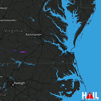 NORFOLK/RICH (KAKQ) RADAR

