This weather event on May 8, 2024 includes:
5 states
21 counties,
64 cities,
and 202 zip codes.
There were 35988 total properties that were impacted and have possible damage.
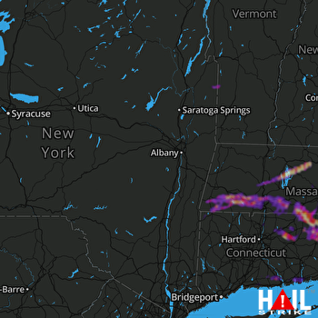 ALBANY (KENX) RADAR
States Impacted By Hail On May 8, 2024
Connecticut
·
Massachusetts
·
New York
·
Rhode Island
·
Vermont
Counties Impacted By Hail On May 8, 2024
Hartford, CT
·
Litchfield, CT
·
Middlesex, CT
·
New Haven, CT
·
New London, CT
·
Tolland, CT
·
Windham, CT
·
Berkshire, MA
·
Franklin, MA
·
Hampden, MA
·
Hampshire, MA
·
Worcester, MA
·
Dutchess, NY
·
Greene, NY
·
Hamilton, NY
·
Washington, NY
·
Kent, RI
·
Providence, RI
·
Washington, RI
·
Bennington, VT
·
Rutland, VT
Cities Impacted By Hail On May 8, 2024
Agawam Town, MA
·
Amherst Center, MA
·
Blandford, MA
·
Broad Brook, CT
·
Brooklyn, CT
·
Canaan, CT
·
Chester Center, CT
·
Chicopee, MA
·
Clayville, RI
·
Conning Towers Nautilus Park, CT
·
Coventry Lake, CT
·
Cranston, RI
·
Danielson, CT
·
Deep River Center, CT
·
East Brooklyn, CT
·
Essex Village, CT
·
Fiskdale, MA
·
Foster Center, RI
·
Gardner, MA
·
Great Barrington, MA
·
Greene, RI
·
Greenville, RI
·
Groton, CT
·
Harmony, RI
·
Hatfield, MA
·
Holland, MA
·
Holyoke, MA
·
Huntington, MA
·
Lakeville, CT
·
Long Hill, CT
·
Longmeadow, MA
·
Mansfield Center, CT
·
Monson Center, MA
·
Moosup, CT
·
New London, CT
·
Niantic, CT
·
North Amherst, MA
·
Northampton, MA
·
North Grosvenor Dale, CT
·
Oxford, MA
·
Palmer Town, MA
·
Petersham, MA
·
Providence, RI
·
Putnam, CT
·
Quinebaug, CT
·
Rockville, CT
·
Russell, MA
·
Rutland, MA
·
Salmon Brook, CT
·
South Amherst, MA
·
Southbridge Town, MA
·
South Coventry, CT
·
South Woodstock, CT
·
Springfield, MA
·
Storrs, CT
·
Sturbridge, MA
·
Warwick, RI
·
Waterford, CT
·
Wauregan, CT
·
Westfield, MA
·
West Springfield Town, MA
·
Wilbraham, MA
·
Windsor Locks, CT
·
Worcester, MA
Zip Codes Impacted By Hail On May 8, 2024
1001
·
1002
·
1003
·
1005
·
1007
·
1009
·
1010
·
1011
·
1013
·
1020
·
1022
·
1027
·
1029
·
1030
·
1033
·
1034
·
1035
·
1036
·
1037
·
1038
·
1040
·
1050
·
1053
·
1056
·
1057
·
1060
·
1062
·
1063
·
1069
·
1071
·
1072
·
1073
·
1075
·
1077
·
1079
·
1080
·
1081
·
1083
·
1085
·
1086
·
1088
·
1089
·
1092
·
1095
·
1097
·
1104
·
1105
·
1106
·
1108
·
1109
·
1118
·
1119
·
1128
·
1129
·
1151
·
1222
·
1223
·
1244
·
1245
·
1253
·
1255
·
1257
·
1258
·
1259
·
1331
·
1355
·
1366
·
1438
·
1440
·
1452
·
1468
·
1473
·
1506
·
1507
·
1518
·
1520
·
1521
·
1522
·
1537
·
1540
·
1543
·
1550
·
1562
·
1566
·
1570
·
1571
·
1605
·
1609
·
1612
·
2814
·
2815
·
2816
·
2817
·
2822
·
2825
·
2826
·
2827
·
2828
·
2830
·
2831
·
2839
·
2857
·
2859
·
2886
·
2892
·
2893
·
2898
·
2907
·
2908
·
2910
·
2911
·
2919
·
2920
·
2921
·
5761
·
5775
·
6016
·
6018
·
6021
·
6024
·
6026
·
6029
·
6031
·
6035
·
6039
·
6043
·
6058
·
6066
·
6068
·
6071
·
6074
·
6076
·
6078
·
6082
·
6084
·
6088
·
6090
·
6095
·
6096
·
6098
·
6226
·
6234
·
6235
·
6238
·
6239
·
6241
·
6242
·
6247
·
6250
·
6255
·
6256
·
6259
·
6262
·
6263
·
6268
·
6269
·
6277
·
6278
·
6279
·
6281
·
6282
·
6320
·
6331
·
6332
·
6333
·
6340
·
6354
·
6357
·
6371
·
6374
·
6375
·
6377
·
6384
·
6385
·
6387
·
6405
·
6409
·
6412
·
6413
·
6417
·
6419
·
6426
·
6437
·
6442
·
6443
·
6475
·
6498
·
12134
·
12439
·
12442
·
12546
·
12832
·
12865
·
1008
·
1028
·
1107
·
1230
·
1264
·
2832
·
2909
·
5776
·
6260

