This weather event on May 5, 2024 includes:
1 states
21 counties,
18 cities,
and 52 zip codes.
There were 1465 total properties that were impacted and have possible damage.
States Impacted By Hail On May 5, 2024
Texas
Counties Impacted By Hail On May 5, 2024
Bee, TX
·
Brooks, TX
·
Calhoun, TX
·
Dimmit, TX
·
Duval, TX
·
Frio, TX
·
Goliad, TX
·
Gonzales, TX
·
Jackson, TX
·
Jim Hogg, TX
·
Jim Wells, TX
·
Kenedy, TX
·
Kleberg, TX
·
La Salle, TX
·
Live Oak, TX
·
Matagorda, TX
·
McMullen, TX
·
Nueces, TX
·
Refugio, TX
·
Victoria, TX
·
Webb, TX
Cities Impacted By Hail On May 5, 2024
Benavides, TX
·
Blessing, TX
·
Cantu Addition, TX
·
Catarina, TX
·
Coyote Acres, TX
·
Falfurrias, TX
·
Fowlerton, TX
·
Inez, TX
·
Lolita, TX
·
Loma Linda East, TX
·
North Pearsall, TX
·
Petronila, TX
·
Port Lavaca, TX
·
Realitos, TX
·
Sarita, TX
·
Three Rivers, TX
·
Tivoli, TX
·
Vanderbilt, TX
Zip Codes Impacted By Hail On May 5, 2024
77419
·
77440
·
77456
·
77465
·
77905
·
77957
·
77961
·
77968
·
77969
·
77970
·
77971
·
77973
·
77978
·
77979
·
77990
·
77991
·
78005
·
78014
·
78017
·
78019
·
78021
·
78022
·
78057
·
78061
·
78071
·
78072
·
78102
·
78104
·
78107
·
78122
·
78332
·
78341
·
78342
·
78349
·
78355
·
78357
·
78361
·
78363
·
78372
·
78375
·
78376
·
78377
·
78380
·
78385
·
78629
·
78830
·
78836
·
78886
·
78959
·
77414
·
77963
·
78384
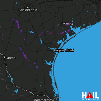 CORP CHRISTI (KCRP) RADAR

