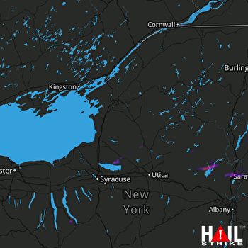
This weather event on April 29, 2024 includes:
3 states
19 counties,
20 cities,
and 60 zip codes.
There were 3129 total properties that were impacted and have possible damage.
States Impacted By Hail On April 29, 2024
New York
·
Pennsylvania
·
Vermont
Counties Impacted By Hail On April 29, 2024
Cayuga, NY
·
Chemung, NY
·
Fulton, NY
·
Hamilton, NY
·
Herkimer, NY
·
Lewis, NY
·
Oneida, NY
·
Oswego, NY
·
Saratoga, NY
·
Schuyler, NY
·
Seneca, NY
·
Steuben, NY
·
St. Lawrence, NY
·
Tompkins, NY
·
Warren, NY
·
Washington, NY
·
Bradford, PA
·
Tioga, PA
·
Bennington, VT
Cities Impacted By Hail On April 29, 2024
Arlington, VT
·
Aurora, NY
·
Boonville, NY
·
Camden, NY
·
Cleveland, NY
·
Corning, NY
·
Gang Mills, NY
·
Greenwich, NY
·
Lawrenceville, PA
·
Millerton, PA
·
Northville, NY
·
Painted Post, NY
·
Rome, NY
·
Saratoga Springs, NY
·
Schuylerville, NY
·
South Corning, NY
·
Speculator, NY
·
Trumansburg, NY
·
Victory, NY
·
West Glens Falls, NY
Zip Codes Impacted By Hail On April 29, 2024
5201
·
5250
·
5252
·
5261
·
12020
·
12025
·
12032
·
12074
·
12078
·
12108
·
12117
·
12134
·
12139
·
12164
·
12190
·
12803
·
12804
·
12809
·
12810
·
12816
·
12822
·
12823
·
12828
·
12831
·
12833
·
12834
·
12835
·
12850
·
12859
·
12865
·
12866
·
12871
·
12884
·
12927
·
13026
·
13028
·
13042
·
13081
·
13147
·
13303
·
13309
·
13316
·
13363
·
13440
·
13454
·
13470
·
13471
·
13486
·
13489
·
14830
·
14850
·
14854
·
14858
·
14870
·
14871
·
14882
·
14886
·
16929
·
16936
·
16946
 FORT DRUM (KTYX) RADAR

