This weather event on April 26, 2024 includes:
4 states
22 counties,
21 cities,
and 57 zip codes.
There were total properties that were impacted and have possible damage.
States Impacted By Hail On April 26, 2024
Iowa
·
Illinois
·
Missouri
·
Wisconsin
Counties Impacted By Hail On April 26, 2024
Black Hawk, IA
·
Butler, IA
·
Grundy, IA
·
Hardin, IA
·
Jasper, IA
·
Marion, IA
·
Marshall, IA
·
Polk, IA
·
Story, IA
·
Tama, IA
·
Warren, IA
·
Adams, IL
·
Brown, IL
·
De Witt, IL
·
Logan, IL
·
McLean, IL
·
Ogle, IL
·
Pike, IL
·
Schuyler, IL
·
Winnebago, IL
·
Marion, MO
·
Rock, WI
Cities Impacted By Hail On April 26, 2024
Albion, IA
·
Beaman, IA
·
Clayton, IL
·
Clemons, IA
·
Collins, IA
·
Colo, IA
·
Hannibal, MO
·
Liberty, IL
·
Marshalltown, IA
·
Monroe, IA
·
Mound Station, IL
·
Newton, IA
·
Parkersburg, IA
·
Payson, IL
·
Pleasantville, IA
·
Reasnor, IA
·
Rhodes, IA
·
State Center, IA
·
Swan, IA
·
Traer, IA
·
Wellsburg, IA
Zip Codes Impacted By Hail On April 26, 2024
50005
·
50051
·
50055
·
50056
·
50106
·
50135
·
50138
·
50148
·
50158
·
50161
·
50168
·
50170
·
50201
·
50206
·
50208
·
50214
·
50225
·
50228
·
50232
·
50234
·
50237
·
50239
·
50247
·
50251
·
50252
·
50258
·
50604
·
50609
·
50621
·
50627
·
50635
·
50638
·
50651
·
50665
·
50672
·
50675
·
50680
·
50701
·
53511
·
61007
·
61030
·
61754
·
62305
·
62319
·
62320
·
62324
·
62338
·
62343
·
62353
·
62360
·
62375
·
62681
·
63401
·
63461
·
62347
·
61072
·
50118
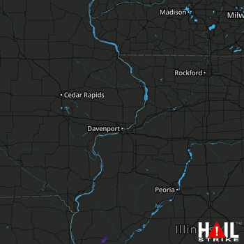 DAVENPORT (KDVN) RADAR

