This weather event on April 26, 2024 includes:
4 states
23 counties,
23 cities,
and 64 zip codes.
There were 2508 total properties that were impacted and have possible damage.
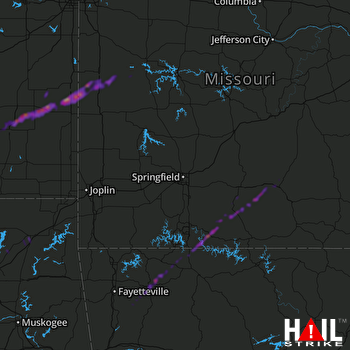 SPRINGFIELD (KSGF) RADAR
States Impacted By Hail On April 26, 2024
Arkansas
·
Kansas
·
Missouri
·
Oklahoma
Counties Impacted By Hail On April 26, 2024
Boone, AR
·
Carroll, AR
·
Madison, AR
·
Washington, AR
·
Allen, KS
·
Bourbon, KS
·
Elk, KS
·
Linn, KS
·
Neosho, KS
·
Wilson, KS
·
Woodson, KS
·
Bates, MO
·
Douglas, MO
·
Greene, MO
·
Henry, MO
·
Ozark, MO
·
Stone, MO
·
Taney, MO
·
Texas, MO
·
Vernon, MO
·
Wright, MO
·
Craig, OK
·
Rogers, OK
Cities Impacted By Hail On April 26, 2024
Ava, MO
·
Benedict, KS
·
Big Cabin, OK
·
Blue Mound, KS
·
Bronson, KS
·
Bushyhead, OK
·
Cabool, MO
·
Foster, MO
·
Fredonia, KS
·
Fulton, KS
·
Green Forest, AR
·
Humboldt, KS
·
Hume, MO
·
Huntsville, AR
·
Kissee Mills, MO
·
Mountain Grove, MO
·
Omaha, AR
·
Prescott, KS
·
Rich Hill, MO
·
Sequoyah, OK
·
Springfield, MO
·
Vinita, OK
·
White Oak, OK
Zip Codes Impacted By Hail On April 26, 2024
64730
·
64745
·
64752
·
64770
·
64779
·
65552
·
65604
·
65608
·
65610
·
65614
·
65627
·
65631
·
65667
·
65672
·
65679
·
65680
·
65689
·
65702
·
65704
·
65711
·
65717
·
65739
·
65744
·
65755
·
65759
·
65768
·
65804
·
65807
·
65809
·
66010
·
66075
·
66701
·
66710
·
66714
·
66716
·
66717
·
66732
·
66736
·
66738
·
66748
·
66749
·
66751
·
66754
·
66767
·
66769
·
66772
·
66777
·
66779
·
66783
·
67047
·
72616
·
72638
·
72701
·
72727
·
72740
·
72773
·
74016
·
74017
·
74301
·
74332
·
72662
·
66755
·
66720
·
64724

