This weather event on April 22, 2024 includes:
3 states
20 counties,
15 cities,
and 71 zip codes.
There were 3001 total properties that were impacted and have possible damage.
States Impacted By Hail On April 22, 2024
Kansas
·
Missouri
·
Nebraska
Counties Impacted By Hail On April 22, 2024
Brown, KS
·
Doniphan, KS
·
Marshall, KS
·
Nemaha, KS
·
Washington, KS
·
Andrew, MO
·
Buchanan, MO
·
DeKalb, MO
·
Gentry, MO
·
Holt, MO
·
Nodaway, MO
·
Fillmore, NE
·
Gage, NE
·
Jefferson, NE
·
Johnson, NE
·
Nemaha, NE
·
Nuckolls, NE
·
Richardson, NE
·
Saline, NE
·
Thayer, NE
Cities Impacted By Hail On April 22, 2024
Agency, MO
·
Barada, NE
·
Beatrice, NE
·
Bern, KS
·
Bolckow, MO
·
Bruning, NE
·
Craig, MO
·
Daykin, NE
·
Elk Creek, NE
·
Fairmont, NE
·
Oketo, KS
·
Plymouth, NE
·
Sabetha, KS
·
Shubert, NE
·
St. Joseph, MO
Zip Codes Impacted By Hail On April 22, 2024
64401
·
64423
·
64427
·
64437
·
64449
·
64451
·
64455
·
64463
·
64466
·
64470
·
64473
·
64483
·
64504
·
64507
·
64670
·
66008
·
66087
·
66090
·
66403
·
66404
·
66406
·
66408
·
66412
·
66434
·
66438
·
66508
·
66515
·
66518
·
66532
·
66534
·
66538
·
66541
·
66946
·
68301
·
68303
·
68305
·
68310
·
68322
·
68332
·
68333
·
68338
·
68341
·
68342
·
68343
·
68348
·
68351
·
68352
·
68354
·
68355
·
68376
·
68377
·
68378
·
68415
·
68416
·
68422
·
68424
·
68437
·
68442
·
68443
·
68444
·
68445
·
68447
·
68450
·
68453
·
68457
·
68458
·
68464
·
68465
·
68964
·
68961
·
66945
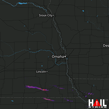 OMAHA (KOAX) RADAR

