This weather event on April 20, 2024 includes:
1 states
19 counties,
17 cities,
and 53 zip codes.
There were 5029 total properties that were impacted and have possible damage.
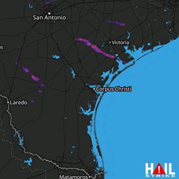 CORP CHRISTI (KCRP) RADAR
States Impacted By Hail On April 20, 2024
Texas
Counties Impacted By Hail On April 20, 2024
Atascosa, TX
·
Bexar, TX
·
Caldwell, TX
·
Calhoun, TX
·
Comal, TX
·
DeWitt, TX
·
Duval, TX
·
Goliad, TX
·
Guadalupe, TX
·
Hays, TX
·
Jackson, TX
·
Karnes, TX
·
La Salle, TX
·
Lavaca, TX
·
McMullen, TX
·
Refugio, TX
·
Victoria, TX
·
Webb, TX
·
Wilson, TX
Cities Impacted By Hail On April 20, 2024
Bulverde, TX
·
Cross Mountain, TX
·
Freer, TX
·
Goliad, TX
·
Grey Forest, TX
·
Helotes, TX
·
Karnes City, TX
·
Lackland AFB, TX
·
Martindale, TX
·
New Braunfels, TX
·
Redwood, TX
·
Runge, TX
·
San Marcos, TX
·
Seadrift, TX
·
Timberwood Park, TX
·
Tivoli, TX
·
Yoakum, TX
Zip Codes Impacted By Hail On April 20, 2024
77905
·
77950
·
77957
·
77960
·
77963
·
77964
·
77973
·
77979
·
77983
·
77990
·
77993
·
77995
·
78001
·
78008
·
78014
·
78019
·
78023
·
78065
·
78072
·
78075
·
78113
·
78117
·
78118
·
78119
·
78130
·
78132
·
78151
·
78163
·
78164
·
78211
·
78225
·
78226
·
78227
·
78245
·
78251
·
78255
·
78256
·
78257
·
78258
·
78260
·
78261
·
78266
·
78341
·
78344
·
78357
·
78371
·
78377
·
78384
·
78644
·
78655
·
78666
·
78141
·
78236

