This weather event on April 20, 2024 includes:
3 states
22 counties,
9 cities,
and 55 zip codes.
There were 724 total properties that were impacted and have possible damage.
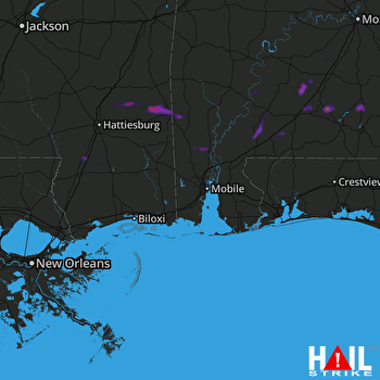 MOBILE (KMOB) RADAR
States Impacted By Hail On April 20, 2024
Alabama
·
Louisiana
·
Mississippi
Counties Impacted By Hail On April 20, 2024
Butler, AL
·
Clarke, AL
·
Coffee, AL
·
Conecuh, AL
·
Covington, AL
·
Crenshaw, AL
·
Escambia, AL
·
Lowndes, AL
·
Mobile, AL
·
Monroe, AL
·
Washington, AL
·
Wilcox, AL
·
St. Helena, LA
·
Tangipahoa, LA
·
Clarke, MS
·
Covington, MS
·
Forrest, MS
·
Greene, MS
·
Jones, MS
·
Lamar, MS
·
Pearl River, MS
·
Wayne, MS
Cities Impacted By Hail On April 20, 2024
Buckatunna, MS
·
Citronelle, AL
·
Excel, AL
·
Lumberton, MS
·
Monroeville, AL
·
Mount Vernon, AL
·
Roseland, LA
·
State Line, MS
·
Tibbie, AL
Zip Codes Impacted By Hail On April 20, 2024
36009
·
36028
·
36030
·
36032
·
36033
·
36037
·
36047
·
36401
·
36426
·
36432
·
36439
·
36444
·
36445
·
36451
·
36456
·
36460
·
36467
·
36470
·
36474
·
36480
·
36481
·
36482
·
36518
·
36522
·
36524
·
36529
·
36538
·
36539
·
36543
·
36545
·
36558
·
36583
·
36761
·
36768
·
39322
·
39355
·
39362
·
39367
·
39443
·
39451
·
39452
·
39455
·
39459
·
39464
·
39476
·
39479
·
39577
·
70422
·
70436
·
70441
·
70444
·
70456
·
36502
·
36560
·
39437

