This weather event on April 20, 2024 includes:
3 states
19 counties,
31 cities,
and 61 zip codes.
There were 45097 total properties that were impacted and have possible damage.
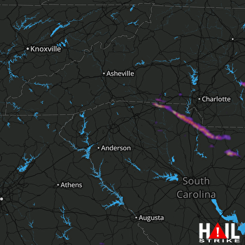 GREER (KGSP) RADAR
States Impacted By Hail On April 20, 2024
Georgia
·
North Carolina
·
South Carolina
Counties Impacted By Hail On April 20, 2024
Jefferson, GA
·
Washington, GA
·
Cleveland, NC
·
Gaston, NC
·
Mecklenburg, NC
·
Montgomery, NC
·
Richmond, NC
·
Stanly, NC
·
Union, NC
·
Cherokee, SC
·
Chester, SC
·
Chesterfield, SC
·
Darlington, SC
·
Kershaw, SC
·
Lancaster, SC
·
Laurens, SC
·
Spartanburg, SC
·
Union, SC
·
York, SC
Cities Impacted By Hail On April 20, 2024
Bethune, SC
·
Biscoe, NC
·
Blacksburg, SC
·
Boiling Springs, NC
·
Catawba, SC
·
Clover, SC
·
Dallas, NC
·
Dobbins Heights, NC
·
Earl, NC
·
Elgin, SC
·
Fort Mill, SC
·
Gastonia, NC
·
Hamlet, NC
·
Hartsville, SC
·
Jefferson, SC
·
Kershaw, SC
·
Lancaster, SC
·
Lesslie, SC
·
Light Oak, NC
·
Matthews, NC
·
McBee, SC
·
Mint Hill, NC
·
Newport, SC
·
North Hartsville, SC
·
Norwood, NC
·
Patterson Springs, NC
·
Ranlo, NC
·
Shelby, NC
·
Springdale, SC
·
Troy, NC
·
York, SC
Zip Codes Impacted By Hail On April 20, 2024
27209
·
27229
·
27306
·
27356
·
27371
·
28009
·
28016
·
28021
·
28034
·
28052
·
28054
·
28073
·
28086
·
28103
·
28105
·
28114
·
28127
·
28128
·
28150
·
28152
·
28173
·
28227
·
28338
·
28345
·
28379
·
29009
·
29020
·
29058
·
29067
·
29101
·
29302
·
29325
·
29340
·
29341
·
29353
·
29364
·
29372
·
29379
·
29550
·
29584
·
29702
·
29704
·
29706
·
29710
·
29715
·
29717
·
29718
·
29720
·
29727
·
29728
·
29730
·
29732
·
29733
·
29743
·
29745
·
30434
·
30803
·
31018
·
31094
·
29374
·
29712

